It’s been a long-ass time since I’ve gotten to do fieldwork. The chance to do fieldwork was at least a minor reason that I chose grad school and OU specifically over other options, drawing on the time-of-life experience during TORUS. Of course, that was three years, a pandemic and a hell of a lot of my enthusiasm for life ago (apparently my advisors measure people’s enthusiasm on a reverse scale of what year of school I’m in. They can’t deal with anything earlier than junior Nolan. I am both deeply offended and also recognize that that’s probably fair). Now, right as my student career comes to an end (job announcement coming soon!), we have a billion covid-delayed campaigns that I could have been an integral part of, possibly to the point of being able to be a lead coordinator on future fieldwork. Instead, I’m a willing gruntwork volunteer. No complaints though, gruntwork can be fun.
The PERiLS project is a project studying QLCS tornadoes in the southeast – how they evolve, why they happen, how we can predict them – all of the lofty goals of whatever year of VORTEX-SE we’re on. The project is a huge multi-institution collaboration, which of course means it has lots of inertia. Fortunately, my role with OU/CIWRO is pretty simple – I’m helping deploy UAS profilers called coptersondes at one of three fixed locations in the Mississippi River Delta in the eight hours leading up to QLCS passage. It’s not the adrenaline rush of getting right alongside a tornado and getting data, but it’s also not the danger of trying to do that with a line of storms in the southeast. Most of the time.
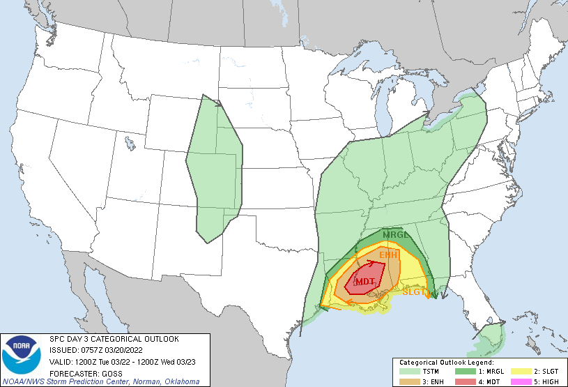
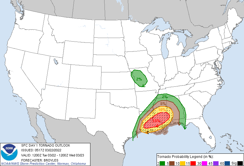
March 22 was our first deployment of the March 1 – April 30 2022 window. If that seems a little late, I think I can safely say that people were getting antsy. The funding contains the potential for 6 IOPs, and so making it nearly to the end of the first month was somewhat suboptimal. However, the first event looked like a real humdinger to make up for it – by the time we were scheduled to leave on Sunday, March 20, a Day 3 Moderate Risk was already in place.
I was assigned to head to Yazoo City, Mississippi, with Liz Smith and Tyler Bell. The two of them obviously know a hell of a lot more about field ops than I do, so I felt pretty secure in the fact that the three of us would do whatever we needed to do, weather permitting. But I also felt like it could be a long weekend through factors largely outside of our control. Any field project is going to prompt complaining, and Liz and Tyler are accomplished professionals in the field of complaining (I think I’m getting better at complaining largely because of their influence. Academia changes a person). Compound that with the late night I’d had on Saturday night rock climbing in the dark with friends, and I was ready to get my snark on.
The vehicle bay at the National Weather Center on Sunday morning was a bustle of last-minute activity, mandatory covid tests, and scientists throwing things into big vehicles. Tony Segales, the designer of the coptersonde, led the three teams that would be going into the field through one final prep session to remember how to inspect and set everything up. NSSL’s media guy took a cheesy video of us and the vehicles pretending to depart:
And a little before 11:00 a.m, we were actually ready to leave. I figured I’d be driving some or most of the time in our big ____ Armada, but to my surprise Tyler informed me that I wasn’t yet eligible to drive it, thanks to weird rental rules. So instead, he would drive the entire way. We stopped at an OnCue on the way out to get snacks. I presciently got some jerky and an apple fritter, having mostly skipped breakfast. This was a very good decision; Liz and Tyler by common assent agreed their would be no lunch today, and we’d instead make blazing time eastward toward our hotel in Greenville, Mississippi. The two of them were very frequently on the same wavelength over the course of the trip, leaving me to grasp at what intention was to be gleaned from their nonverbal or limited-word cues. It would be enough to drive a normal person insane, but I guess I have abnormal patience for being out of the loop. The three of us all bonded over our shared loathing of PERiLS briefings, which somehow make TORUS briefings from 2019 seem succinct. This one, which dragged on for nearly two hours, should have been pretty simple. All we needed to do was pick a target area for the non-profiling teams. And yet, as I said, it took an hour and a half and a lot of heckling from Coptersonde Team 1. Liz was one of the final decision-makers, and naturally the vote for either the Mississippi Black Belt or the Louisiana Delta region ended up tied 2-2. I thought she might spontaneously collapse when one of the other decision makers suggested flipping a coin to decide. Instead, she managed to calmly persuade them to reason a decision, and the entire PERiLS team was bound for the Black Belt (much to the joy of the incorrigible Tony Lyza, one of the project PIs).
The three of us led the charge across I-40 to Little Rock and then down into the southeast corner of Arkansas, a Delta land made up of squishy fields and older towns. I had little to do but work fitfully on my thesis, watch March Madness on my phone, and stare out the window at the endless barren plots. Finally, with the sun sinking down behind us, my agricultural view was replaced by swamps, and then a large bridge over the lower Mississippi River, and then some more swamps. A few more minutes and we’d finally reached our resting spot for the night: a Holiday Inn that was undergoing extensive-looking renovations. I was immensely relieved to discover that my CIWRO travel card worked in its first-ever in-person use at the front desk. We hauled the coptersonde out of the car and into Tyler’s room, I dropped my bags off in my (own personal! With two beds!) room, and then went back to the lobby to await the other two coptersonde teams.
They had stopped for lunch, unlike us, and took a while to filter in. By this point, I was hungry enough to be ready for whatever the group decided. But, because it was Sunday night in a small town, our options were limited. Eventually, someone found a sports bar called Rivals out on the edge of town that was still open at that late hour. The drive there had me wondering if all of the coptersonde noobs were going to get dropped off in a muddy field and forced to walk back – it was completely dark out in the countryside, and that felt like a classic hazing tactic. But instead, we pulled up to the restaurant, which was run by a friendly staff and featured a catfish platter that everyone seemed to default to. Obviously I’m not a huge catfish guy myself, so I stuck with a chili burger and fried pickles.
The food itself was pretty dang good. Considering it was my only meal of the day (a phenomenon now known in the field as Meal), I was probably biased towards it, but I’m not complaining. The conversation was lively, from Tony asking me about SPORTS because I was yelling at a March Madness game on the TV at the bar to Connor Bruce’s relationship anecdotes. Everyone seemed loose and like they were having a pretty good time, although I became a minor and accidental butt of the dinner joke when I asked for napkins for my chili burger and the server came back with a whole stack. I ate very carefully, because the only thing worse than being the guy who got a whole stack of napkins for his meal is being the guy who needed it.
I was flat-out beat by the time we got back to the hotel. There were still a couple of opening-weekend tournament games on that I could watch from my room, but I found my eyes closing of their own accord almost instantly. Sunday, March 20 had drawn to a close.
Monday, March 21 started early. Like, really early. Like, some kid turned on the alarm in the hotel room at 12:00 a.m. and I woke up in a panic. Hitting enough buttons turned it off, but it took a while to let the adrenaline wear off and get back to bed. This time, I was able to get some dang peace and quiet until around daybreak, when I groggily got out of bed and got ready for the day. The Holiday Inn at least had some things available for breakfast, including some really delicious cinnamon rolls that helped reconcile me to the world. I was even half-awake by the time everyone got downstairs and the two coptersonde teams that were going to be deployed elsewhere than Greenville (including my own) had checked out. The mission was out the door pretty early in the morning. It was going to be a longer day of prep for the following morning’s deployment than I initially realized.
First of all, all nine coptersonde launcher people drove back across the river to Lake Village, Arkansas, site of CLAMPS1 and the western coptersonde launch location. Not only did Liz and Tyler want to show the location and its amenities, but we were also going to do one last practice deployment before the Real Deal tomorrow. Tony walked through a backup version of the software that he had installed last-second after a malfunction to the primary one, the team (Brian, Connor, and Arianna) got their UAS in the air, and I got to enjoy the sites and smells of a scenic Arkansas lakeside RV park.
It was a lot sunnier than I had expected a southeast severe storms deployment in March to be, so I didn’t have sunglasses. We all learn lessons, I guess.
With that, the Lake Village team was left behind to do whatever they ended up doing with the rest of their Monday. As for the remaining two teams, we were due to cross the Mississippi River once more and head to the small town of Schlater. This was the rural-est of the three sites, and the team here would be lacking the comparative comforts of a CLAMPS trailer. This could have been a downside, but I don’t think it was, after seeing where they were located. At first, Tyler pulled into a random field and I thought to myself that that could be brutal. But it turned out that I just wasn’t paying attention, and it was just time for a (mercifully) much shorter briefing than the day before. Once that was done, we headed a little further to a tiny airstrip near Schlater where two old men have been operating crop dusters for decades. These dudes were the picture of southern hospitality, offering use of the little office coffeepot whenever the team wanted. The second team (Tony, Austin, and Alyssa) had it made down to the level of getting to pet the two office cats once it started raining.
Finally, it was just our Nissan Armada driving southbound through a sunny Delta afternoon. Time rolled by until near mid-afternoon when we finally got to the northern edge of Yazoo City. For the first time, I saw where I’d be operating much too early the following morning. The Piney Creek RV park was nestled on US highway 49E with horse pastures to the north, a big industrial complex to the south, and train tracks preceding cropland across the road. It was pretty open, and CLAMPS2 was right by the entrance. I liked it, minus the fact that I didn’t see any facilities if I needed to go the bathroom. In the short term, I could help Liz and Tyler calibrate the AERI on a “clear-sky” day by helping them launch a radiosonde to compare retrievals to. Kind of.
It was only partially my fault, Liz was the one who actually said “ready?” while we were standing in the shadow of the tree. When you think about it, I was really just a copilot. Sheepishly, I helped get the next one properly into the sky and we packed up to finally get Meal for the day. By consensus, and owing to the weird closures of restaurants that evidently affect all of Yazoo City on a given day, we went with El Sombrero Mexican restaurant. As a lover of Mexican food, this sat alright with me. You can’t always trust Mexican food in a small town, but the fact that this was my only food (outside of some sunflower seeds) I’d had since breakfast made the four green enchiladas I had taste heavenly. The meal was interrupted by Jason calling me – there was a tornado outbreak just beginning across much of Texas, and he wanted my advice on positioning. I warned him against the (rather foolish) spot he’d picked to wait for his storm to go by, then went back to dinner without a second thought. If anything, I was annoyed that Liz and Tyler had ordered margaritas without me. Meanwhile:
Jason was selling his footage for hundreds of dollars. He was kind enough to offer to buy me a steak.
I felt much better after getting some food inside of me. A lot more tired, but also less cranky. Liz and Tyler called for an all-coptersonde Google Meet at 5:15 to discuss what time to deploy the next morning. In the interim, I very nearly fell asleep in my Hampton Inn bed (only one bed in my room this time, a true tragedy). I managed to rouse myself in time to get the gist of the briefing from Tyler’s room. Although nobody *wanted* to start early, the strictures of the the experiment were stacked against us. The coptersondes were designed as pre-storm profilers to be deployed as close to eight hours in advance of QLCS passage at the furthest site as we could guess. In this case, the site was obviously Yazoo City, and CAMs showed the line getting to us somewhere in the range of 18Z or so – in other words, 1:00 p.m. You can do the math backwards and realize what time that meant we’d be starting. It was a nerve-wracking forecast, too, because the likeliest evolution would be a decaying squall line impacting just west of Yazoo and then the real QLCS passage along the remnant outflow towards early afternoon. But if CAMs were too slow/weak with the decaying squall line as they often are…
We officially set a first launch time of 5:00 a.m. the next morning and I wandered outside to get some provisions from the Wal-Mart directly behind the Hampton Inn. I hadn’t done a great job of packing snacks for the trip, and this would give me a chance to get some stuff to keep from starving before Meal tomorrow. Plus, Liz had gotten lots of meat with her skillet at El Sombrero and Tyler asked me to get some eggs and tortillas so we could make breakfast tacos with the leftovers. I happily obliged:
That’s true breakfast of champions shit right there. I walked the stuff back up to my room and stuck in the fridge, then faced a true fieldwork dilemma. What to do with the rest of my night? I could work on a take-home exam that I had to do that week (I at least had gotten my due date extended to Friday). I could work on my seminar. Heck, I could work on my thesis. Or, I could do what I actually did in the thick of exhaustion: read a book and scroll through Twitter as a localized tornado outbreak occurred right in the thick of the Austin metro. I did that until around 9:30 when I realized that I needed to be up in 6 hours, and then immediately conked out.
When I awoke at 3:45 I noticed a couple of things. First of all, it was going to be a long day:
Second of all, my Fitbit was missing somewhere. It took me 10 minutes to blearily track it down under the nightstand. Between that and gathering the groceries, I was unsurprised to see Tyler and Liz waiting for me in the Hampton Inn parking lot when I got downstairs a little after 4:00. We headed out to the Armada in the darkness and drove silently up to the Piney Creek site. Still operating quietly in the night, the three of us set to prepping coptersonde operations by the red light of our headlamps and the orange light of my glow wristbands. I got the UAS box out of the back of the car, then walked over to the front of CLAMPS where the folding table was sitting ready for use and set it up. Within a few minutes, the site was coming together. I pulled out my laptop to set up the various checklists that one must submit pre, during, and post-flight. As a visual observer, my primary job was to fill out and submit each checklist. Other than the fact that I didn’t actually know where the checklists were on the Drone Logbook website, everything was going great so far. After floundering for several minutes, Tyler mercifully bailed me out and pointed me to the right spot. He prepped the UAS, a big grey drone, while Liz prepped the software that the UAS gets its flight program from. I hurried through the checklist and checked a flight radar app on my phone to make sure we’d have unrestricted airspace. Spoiler: at 5:00 a.m. in rural Mississippi below 5,000 feet on a cloudy day, yes we would.
At 5:00 sharp, three different coptersondes in three different locations simultaneously rose in the air, with an autopilot function turning the UAS into the wind a few meters off the deck before it began a rise. Three pilots flipped strobe lights on once their respective drone was high enough not to blind the people on the ground. Three ground station operators called out height above the the ground and other pertinent details. And three visual operators ripped through their checklists and electronically signed them.
The first flight outlined some of the difficulties we would deal with that morning. For one, little showers had developed in the low-level jet axis and one of them rained on us uncomfortably in Yazoo City while the UAS was still in the air. My laptop was rapidly coated with a misty rain. What’s more, the squall line looked to be ahead of schedule. Already, the Lake City sight was threatened by nearby lightning. And to add a cherry on top, the low-level jet was so strong that our UAS triggered its “return-to-home” failsafe with 25 m/s winds (55 mph)… at about 300 meters off the deck. A short flight, but a merry one, as we could see the low-level stratus deck lit up in the industrial glow racing overhead. The drone returned to the launchpad, and I flipped to my post-flight checklist. Once that was done, I closed my laptop to prevent the heavier rain from streaking my screen any worse than it already was, grabbed my Tigers blanket, and retreated into CLAMPS to stay warm and dry.
Soon after, the shower moved away and Liz improvised an umbrella clipped to the table to keep us dry from the next one. I felt tolerably better-set-up for the 5:30 flight, which met a similar fate. All the while, we stayed apprised of the other two teams via the NSSL internal chat client. Lightning was inching ever-closer to Lake Village, but otherwise things were going as well as one could hope. The axis of showers moved off to the east and my spirits rose accordingly. More importantly, Tyler had brought his French Press and backpacking stove. Nothing will bring you into the life of field science like sitting inside a cramped trailer well before sunrise, sipping coffee while listening to the background hum and clicking of the profilers in the trailer.
Speaking of sitting inside a cramped trailer – it had barely been an hour when CLAMPS1 entered the decaying squall line around 6:00. Liz gave the coptersonde team there discretion to leave when they wanted, but Brian, Connor, and Arianna chose to ride it out and see if they could get more profiling done later. Instead, they got to spend the entire morning inside CLAMPS with no internet while remaining in the stratifrom. Fieldwork!
That was a them problem, not a me problem. In fact, as the first light of dawn peeked through, I realized that the sky was beginning to clear.
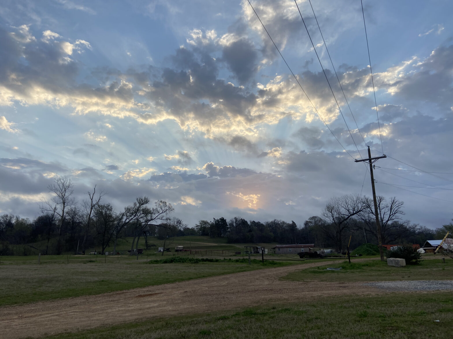
That’s always a scary sign inside the dry slot. For our purposes, it led to a beautiful sunrise, including some pretty anticrepuscular rays over the elevated showers to our east and constant, turbulent ribbons of stratus around 300 meters within the core of the low-level jet.

I settled into a nice little pattern – label each checksheet with the the time of the flight. List the battery number on the pre-flight checklist, then list the battery’s voltage. List the altitude of and reason for termination of the flight on the in-flight checklist (usually termination due to the wind, although as the skies cleared and the LLJ broke down we made it to cloud base a few times). List the final battery voltage on the post-flight checklist. In between, monitor radar and the HRRR for Liz and Tyler who were obviously a bit too busy to do that themselves. And, of course, when the coffee had run through me, find a wooded spot along the dirt road following Piney Creek to do my business quickly before rejoining the other two. The 30-minute flight launch time sort of belied the fact that each launch was lasting five minutes at the most with the low cloud deck/wind threshold. That meant we needed to spend five minutes prepping a flight, five minutes doing it, then twenty minutes milling about. The best twenty minutes was undoubtedly used by Tyler to heat Liz’s skillet meat on his camping stove, then scramble some eggs in it to make breakfast tacos. I have to agree with Tyler’s assertion that food tastes 200% better when you’re camping, and that transferred over to these tacos while deployed. There was beef, chorizo, chicken, and even shrimp (which I studiously avoided). Combine that with some eggs and salsa inside Wal-Mart brand tacos and you get to heaven.
We briefly went to 15-minute coordinated flights around 8:00 as the Schlater team prepared for boundary passage and termination of their operations, then went back to 30 minutes when they, too, passed into the valley of the shadow of rain. And then there was one.
The three of us kept plugging along as we passed the midway point on our allowed flight window. I didn’t think there was much chance that we could keep the storms away until 1:00, but the later they stayed away, the likelier that we would have problems when they got there. I kept an eye on it, when I wasn’t busy with other very important matters.
All horses like me, obviously. I couldn’t imagine a horse that wouldn’t want to eat some grass offered by myself.
The brown horse is a meaniehead and I refuse to acknowledge its existence.
In more serious matters, the outflow boundary from the overnight squall had made it within a few miles of our site. Weak storms continued to fire due north of us, but somehow we managed to thread the needle and avoid storm development overhead. The remnants of weather balloon sitting in the tree across from us blew at us in an indication that the wind had shifted – outflow boundary passage had occurred. For a lot of people, this would be sad – after all, tornado potential on the cool side of the boundary is near nil. But for three boundary layer scientists, this just screamed “opportunity”. Under the watchful eye of two Jackson State students and their advisor (here to observe us and see if they wanted to join the project as volunteers for future IOPS), coptersonde launches at Piney Creek continued. In fact, as Liz was showing the students around and explaining operations, I got myself a short-term promotion from visual observer to ground station operator. Over the course of that time, nothing disastrous happened, although the coptersonde failed to sync GPS data on one launch so Tyler had to fly it manually. That’s just one of those things that happens during fieldwork – all of us were finding little things that the coptersonde did that maybe it wasn’t exactly supposed to do. Nothing affected the collection of data, so at the time that’s just one of those things you file away for later and don’t worry about.
The atmosphere put on a show for us in the latter stages of our deployment. The boundary that washed over us was weak and shallow; it didn’t stand a chance against the ripping low-level southerlies once it had detached from the weak storms to the north. That meant that while the Jackson State students looked on, we had a trapped stable boundary layer that in one launch Liz estimated was just 70 meters deep. In the next, I had it at no more than the 10-40 meter layer. The cool air became still and rapidly warmed through mechanical mixing. Finally, a big gust of wind out of the south announced what we had been sensing – Piney Creek was back in the warm sector, with all of the attendant tornado dangers. Back to our west across Louisiana, the day’s main event was rapidly ramping up with a forward-accelerating QLCS tracking toward us. The question in my mind was – would we get the northern, junkier storms, that still enveloped Lake Village and Schlater, or would the cutoff between surface-based and elevated convection happen essentially overhead? Because if that was the case, and we stayed right on the boundary, things could get pretty ugly here.
The answer turned out to be some sort of mixture of the two. Some junky, near-surfaced based storms developed to the west of Yazoo City:
But at the same time, on a path just to our southwest, a circulation developed that I declared would likely be tornadic rapidly. This was correct:
If you trusted that tornado warning, the circulation would slide safely off to our south. But the minutes slid by and the situation got a bit sketchier. We got a last flight in at 11:30, ending six and a half hours and 16 flights of operations. Then, the three of us settled in to wait and see what our fate would be. Liz and Tyler had smartly begun moving everything inside CLAMPS that we didn’t want to get wet. Everything wasn’t necessarily packed up and ready to go, but it was ready to ride out a storm. The first severe storm sideswiped us as its base went by just to the north:
It quickly went undercut and whooshed out a big bucket of cold air. I breathed a little easier, but only a little. Because the storm to the southwest was indeed occluding west toward us, and the only way I can describe what I saw is that the apex of a little hook shape was pointing nearly directly at our site. I had this gut feeling that I can’t quite describe, and it was bad. But I didn’t want to be the “cry-wolf” guy, especially after Mike had specifically expressed confidence in me to keep an eye out on radar. Besides, a QLCS can be a true game of whack-a-mole: we could drive away from the CLAMPS site and directly into another developing tornado, and a car on the road is probably less-equipped to handle a weak tornado than a trailer that’s been battle-tested in 90 mph winds. So as the rain and thunder picked up at our site, all with incongruous cold northerly winds, the three of us huddled inside CLAMPS, silently watching RadarScope on Tyler’s laptop. In the silence, the tone of WEA on Liz’s phone made my blood run cold. Hopeful speculation that maybe it was an enhanced severe warning ran out when I got the tone 10 seconds later, declaring a tornado warning for our location. It appeared the Jackson had issued a blanket tornado warning for three mesovortices, the northern one of which may head right toward us. Velocity showed turbulence associated with stable air over us and to the north, but lifting rapidly. Alarm bells were going off in my head.

The three of us discussed options: ride it 0ut, drive north, or hightail it to the Hampton Inn. Given the whack-a-mole nature of the mesos, Tyler suggested that we go back to the hotel. I said, “We don’t have a lot of time if we want to do that”, to which Liz had the only natural reply: “Are you ready to go?” I scooped up my laptop and iPad and we ran out into the downpour to the car. I threw open the door, dropped my stuff next to me, and buckled in as Tyler somehow simultaneously turned the ignition, threw it into reverse, and hit the gas. We whipped out onto the highway and he floored it back into town. As we pulled into the Hampton Inn parking lot, I took note of the American flag: starched out of the north.
The front entrance to the Hampton Inn was a beehive of activity. Guests and employees were shuttling in and out of the hotel trying to take shelter or see anything, all while Yazoo City’s tornado sirens wailed intermittently nearby. Instead of running inside like I should have, I hunched over into the front entrance wind, bent over my laptop and iPad to keep them from getting soaked. There was nothing of note to see: just more clouds streaming southward. Locals who had gotten wind of who we were asked questions, which Liz answered as patiently and honestly as she could. To be blunt, though, if we couldn’t tell what we were looking at, who else could?
The moment of truth came and went, and the gust front passed us by. No tornado. I breathed a sigh of relief that I hadn’t entirely realized I was holding in. *That* had been sketchy. I know that southeast research is going to end in some sketchy situations, but that had been a lot to bargain for. We went into the lobby to inform the guests and employees that things were safe – though Liz took care to state that the safety was just “for now”. And then we went back out into the pouring rain from whence we had emerged just a few minutes ago, this time to quickly clean up CLAMPS so we could call it a day.
No sooner had Tyler gotten back onto the main road than I idly looked west into the driving wind and rain – and saw a blue glow less than a quarter mile away. “Power flashes. Due west!” I exclaimed. Tyler dutifully whipped the car into a tight U-turn right back into the parking lot, and back inside we went. By then, we had calmed down enough to establish that the power flashes were part of the intense straight-line rear-inflow jet that had settled over Yazoo City, but still, we didn’t need to go out into that. So that’s how we re-entered the Hampton Inn, much to the razzing of the staff and guests collected in the lobby. I moved off to a corner, not wanting to deal with that, and watched the wind and rain hammer this part of town. Little did I know it, but this RIJ surge triggered a half-mile-wide tornado a few miles to our east.

To put it bluntly: we were fortunate that the storms took just a few more minutes to intensify. It could have been worse.
Wearily, the three of us went back to clean up our trash and secure the coptersonde. The rain continued to fall heavily over Piney Creek, turning the bottomlands into a swampy, gooey mess.
And then for the last time we left the deployment site. It had been quite the day, as Liz later said:
But for now all I could think of was taking a shower and falling asleep. Of course, with the power out in most of Yazoo City there was the issue of figuring out how to shower inside a completely dark bathroom. I figured I’d solve that by setting up my glow bracelets and making a rave shower, which looked really cool and I was looking forward to using, but then the power came back on in the hotel. The spell was broken and I sheepishly turned the light on.
The rest of my day was mostly spent in a drunken stupor of exhaustion. We had a debrief with the other coptersonde groups that I was too tired to go down to Tyler’s room for, so I attended from bed. Then I waited forever for the two of them to pick out a crawfish restaurant to go to, only to get there and find a power pole leaning against the roof. So instead, we went to a steakhouse called Ribeyes, where I got a deliciously country-fried steak and also accidentally put sour cream on top of my roll thinking it was butter. So, you know, exhaustion comes for us all in different ways. I was in bed nice and early that night.
The trip home from Yazoo City to Norman was long and boring as hell. The three of us were probably even complainier than we had been on the way out. To be honest though, there was much to have been encouraged by. The coptersonde teams had survived without major malfunction and one of the three sites had collected some pretty awesome data. Meanwhile, the rest of the PERiLS IOP appeared to go well in the eastern part of the state of Mississippi, where multiple supercell-QLCS mergers occurred with significant tornadoes and researchers all over it. One has to understand that the bar changes a little bit with missions down in the jungle; appreciate your own safety first, and your data second. By that count, the first deployment of the year had gone pretty well for us.
“Tony Delgado” is actually Antonio (Tony) Ricardo Segales Espinosa. Not sure where Delgado came from….
Thank you for catching that! I have no idea how I did that either, to be honest. Corrected!