
For some people, exam week means endless cramming and all-night study sessions. May of 2019 featured an active weather pattern, so for me it included a jaunt to the Caprock region to chase a Panhandle moderate risk. On Tuesday, May 7, the SPC outlined an area with a 15% tornado risk. I had met with Todd Lindley of the NWS Norman office during the morning hours, and at the end of the meeting we discussed the potential for discrete convection to develop along the I-27 corridor toward mid-afternoon. My early thinking was that storms would likely grow upscale rapidly, and CAM trends seemed to tilt that way. Still, with increasing wind shear in mid-afternoon and ample boundary-layer moisture for storms to enter as they approached the Caprock, I could see the potential for discrete updrafts to produce tornadoes.

James, Bradley and I hopped into James’ Mustang (awful chase vehicle) around noon and headed west on I-40. By the time we reached Shamrock, Texas, toward mid-afternoon, it became clear that we were going to have choose between a north and south target. Both the RAP and Warn on Forecast model suggested an early and likely intense storm on the west side of Amarillo, near the merger of a dryline and synoptic front. Further development was expected down the dryline from Amarillo to Lubbock to Fort Stockton (yes, there was a Fort Stockton tornado). James and I agonized over whether to commit north or south. A storm was developing near Edmonson, and moving northeast to where we could easily intercept. However, the anticipated storm near Amarillo was just west of town and chaser reports on social media suggested it was rapidly getting its act together. Because of that, and because of the signal Warn On Forecast showed, we continued west on I-40 and skirted around the northeast side of Amarillo to US-87.
My unease with our decision grew with each passing minute, particularly as we shot up from the south into the storm’s powerful rear-flank gust front. Taking heavy rain and gusty winds on the north side of town, I was forced to reckon with the fact that due to Lake Meredith, another eastbound option to keep up with the storm didn’t exist until Dumas. Furthermore, the storm was an HP mess and would parallel the Canadian River throughout its life cycle. Although the storm and several others along the front went on to produce tornadoes during the next few hours (perhaps a foreshadow to the May 23, 2019 event), I felt like our chances were better off to the south.
![[GIF]](https://vortex.plymouth.edu/myowxp/maps/16065.gif)
The immediate concern for us was: because of my decision to play to the north, we now needed to get south ASAP. US-87 was a nightmare of traffic lights through the center of Amarillo, and to compound my angst our merge onto I-27 was slowed due to construction. By this point, I was in a pretty rotten mood, particularly as reports filled in about a tornado on the ground near Edmondson.
As we raced south on I-27, it became clear that we weren’t going to beat the supercell – the forward flank was already over the highway, and the storm was producing very large hail. This left a tricky choice for me as the navigator – make a safe play and exit the highway well north of the forward flank, then trying to cut east and south ahead of it, or play with fire a bit and cut south through the forward flank. To compound matters, Palo Duro and Caprock Canyons are just east of I-27, and the routes to keep up with the storm would be pretty limited – either east from Silverton to Turkey, or all the way back north to Claude.
As minutes passed by and the forward flank lightning core approached, I continued to eschew east routes in favor of getting further south. After consulting with Bradley (who gave me a noncommittal answer), and James, who was clearly concerned I was trying to kill his car, I ultimately elected against trying to punch into the bear’s cage right on I-27, with the very large hail core likely to be on or right next to the Interstate as we passed it. Instead, we made our move halfway between Happy and Tulia, exiting the highway in steadily intensifying rain and darting east several miles.
When we reached our appointed turn south, Ranch Road 146, I remember hesitating for a second before telling James to turn. Core punching isn’t something we were used to doing, and this one clearly had the potential to drop softballs. After looking at radar one last time, I turned to James and said, “We’re going to get hail if we go south. We may even get some large hail. But we won’t get any giant hail, because that’s back by the meso”. And then I prayed that I was right as we accelerated south.
Within seconds, the heavy rain was accentuated by the plinking of small hailstones against the roof of his car. Those crescendoed until hail was louder than rain, and ice covered the road ahead of us. James did a phenomenal job of maintaining composure on the slippery road, and it turned out that my statement was correct – the largest hail was nowhere near enough to dent his car. Directly ahead us, a shape emerged from the gloom ahead – the meso was directly in front of us.
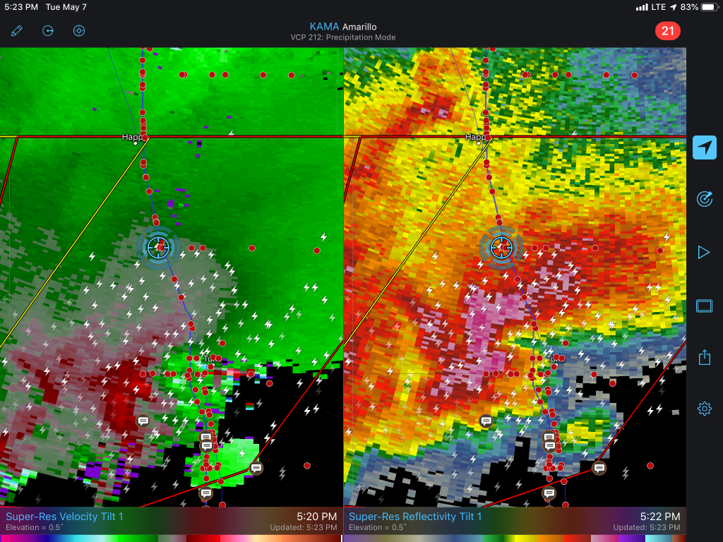
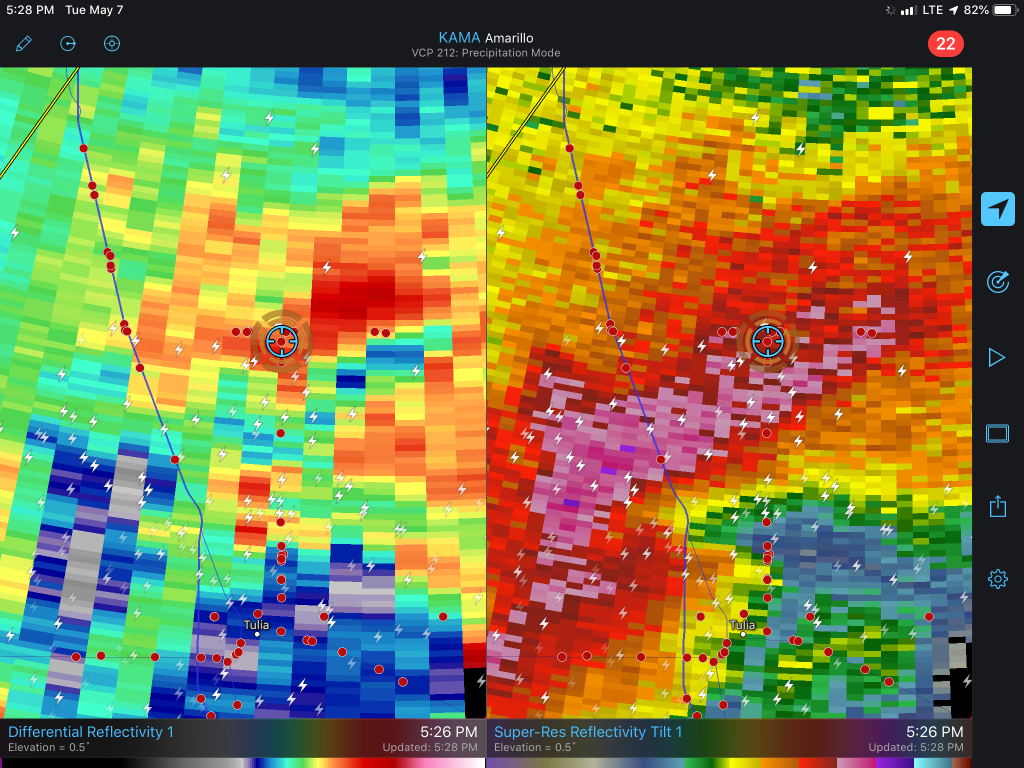
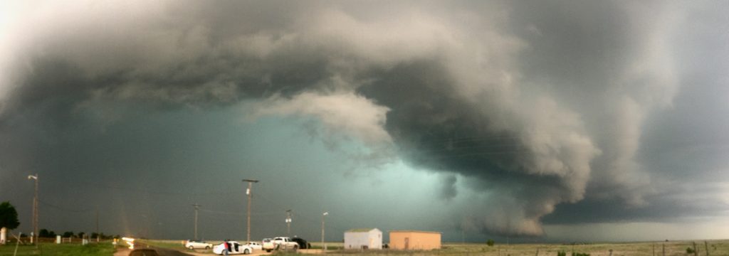
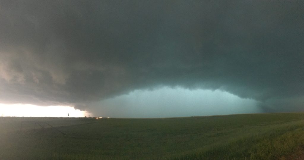
At this point, I was hooting and hollering and carrying on. We emerged from the rain and turned onto Ranch Road 1318 east of Tulia, with a massive HP supercell just to our west. It had a powerful rear-flank gust front on its south side similar to the supercell near Amarillo earlier, but no tornado on the ground that we could discern. As we watched, and RFD surge began to our northwest, beginning a wrap-around of the rain curtain obscuring our view of the meso (seen below just right of the wall of rain). It was clear we’d either have to reposition downstream, or enter the inflow notch.
Just before 6:00, we turned north on Ranch Road 2301 and began paralleling the RFD gust front. At 6:00, we got a view of the meso directly to our west, with some of the wildest rotation I’ve ever seen. A huge inflow tail curled into the storm from the northwest, with the RFD gust front visibly swinging around it. I managed to capture about 3 minutes of video (to be uploaded when I plug in my camera to my laptop while I’m editing this blog at a later date), showing this occlusion process of the circulation.
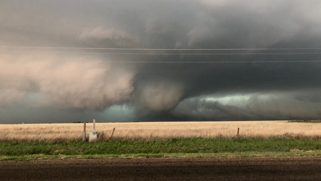
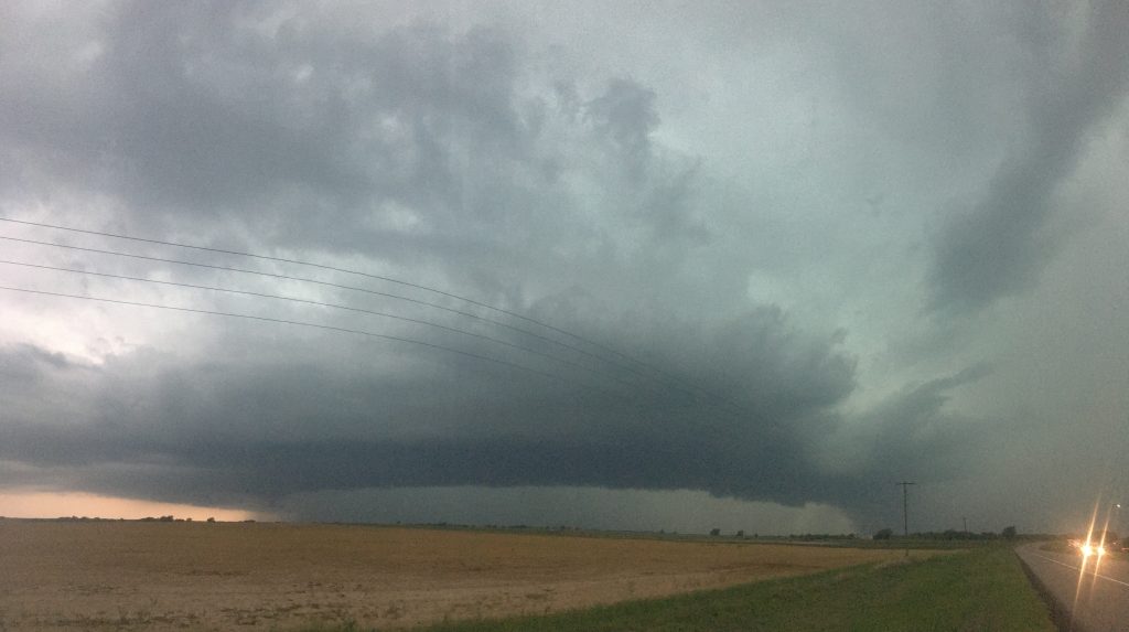
I was pretty flabbergasted by this motion, and figured a tornado was on the ground or would be very shortly (the tornado, according to the NWS, began around 5:56 p.m). However, as the effective bear’s cage continued to consume the circulation, we felt like our only option was to slide further and further into the notch. Finally, we ran out of gridded options. We were fully pinned against Palo Duro Canyon on FM 285, and would have to take State Highway 207 north to Claude. As we travelled east on 285, hailstones from the forward flank occasionally pelted the car. I’ve never seen such a glow in the bear’s cage as this one.
According to the NWS survey, which found no DIs, the tornado had lifted about 7 minutes prior to this. However, we were busy navigating State Highway 207 in a train of slow-moving chasers as we descended the walls of the canyon. The forward-flank hailstones grew in size, until we were getting thwacked by stones large enough to leave decent-sized dents in James’ car. I’ve searched the NWS database and the largest hail confirmed from Armstrong that day was… 1.75 inches. We assumed we were taking tennis balls at the time (and afterwards, given the dents in his car), but I suppose that we may have been overestimating. In hindsight, telling Bradley to put his backpack against the back of his neck in case a renegade stone hit the back windshield was probably unnecessary. Either way, when we finally emerged into the clear air ahead of the storm, we repositioned east toward Clarendon and awaited the next cycle of the storm. By this point, the RFD gust front was massive.
I wanted to see if we could get one last chance to see the storm, which produced a tornado near Howardwick. We paralleled its path along State Highway 273 toward McLean, then along the I-40 frontage road west toward Alanreed. Unbeknownst to us, the tornado that existed toward Alanreed, once again heavily rainwrapped, lifted before it reached I-40. We cautiously picked our way through the rain toward the spot where the remnant circulation would cross the road, with a stiff southerly wind the whole time. Finally, James abandoned the pursuit, which was just as well as the inflow notch had completely filled in with rain and daylight was fading away.
Immediately after turning around on I-40, we were treated to the sight of a car hydroplaning off the Interstate right in front of us. We continued to fight through cells through the eastern Panhandle and into western Oklahoma, where later that night a strong tornado would impact Cordell. It was a day where we were challenged by the high-precipitation nature of the storms, but I was proud of our navigational moves after the initial false start toward Amarillo.