Ever so slowly, I was acclimating to not being on midnight shifts. It helped immensely that we were on the West Coast a full two hours behind central time, but by Sunday, October 15 I actually felt sort of human. A long night of sawing logs (you’d have to be crazy not to be exhausted after the day we’d had on Saturday) seemed to have done wonders. So did a breakfast at the Holiday Inn Express in Newport.
It would have been easy to assume that we’d already had our signature day along the Oregon Coast. Maybe in some ways we had – Drift Creek Falls was such a unique hike unlike any I’d done before that that one will stand the test of time in my memory. But in terms of pure coast stuff, the stretch that we planned to drive south from Newport to Florence today was going to be so, so much cooler than the stretch from Newport up to Pacific City. It was stunning, in the best sort of way.
An early indication that our fortunes were on the up and up was provided by the weather when we left the hotel. While the cold and rainy prior two days had been a blessing for someone who was still dealing with an obnoxiously warm first half of October in Oklahoma, this morning the sun was trying to peak out through the fog and mist, and it was altogether welcome. Visibility kept going up and down between Newport and our first stop in the town of Seal Rock about 10 minutes to the south. Unlike the day before, I was no longer on the hook for itinerary-setting. And unlike me, my dad was a smart customer who had planned a coffee stop directly at the start of the day at Seal Rock Espresso and Bakery. Score one for Rich, who knows how to keep certain others (hi, Elizabeth!) from going without their coffee. I can stand to learn much from him.
Our first sightseeing stop of the day was at the Seal Rock State Recreation Site, a little parking lot right off of the Oregon Coast Highway. From the parking lot, a trail led for about a minute through some scrubby beachside trees (with some of the largest mushrooms I’d ever seen sprouting right next to the path) to a bluff overlooking the beach.
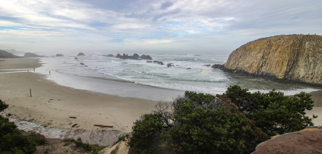
The tide was flowing in rapidly, but there was still plenty of beach to go walk along. My mom and Elizabeth began strolling down the sand to the left, while my dad and I went for the more high-risk, high-reward option of staying to the right, where a field of loose rocks led to the shorebound side of the big basalt column on the right of the image above. The reward? A jet-black cove of basalt columns that was rapidly filling with the onrushing tide, carrying a bunch of little shells and horrible smells closer to us with each wave.

We were hoping for some tidal pools, and I bet a half an hour before we got there the bottom of the cove would have been filled with little tidal organisms. But the last of the pools were just getting washed out by the time I finished scrambling down to the beach. Of everything cool we saw in Oregon, a starfish just barely peeking above the waterline the day before at Yaquina Head was the only “tidal” wildlife we got.
The beach was also a really, really cool experience. Just to the left of the big rock (Seal Rock, maybe?) the tide was sloshing up in just the right way that at one point to reflect the rock in the background.
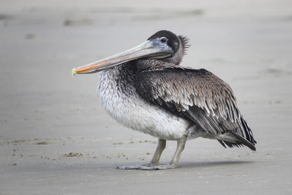
We wandered down the beach toward where my mom and Elizabeth were. They were at the mouth of a small creek, enjoying the last parts of their coffee and avoiding a particularly belligerent-looking bird. To my knowledge, I believe it was a brown pelican. And while it looked belligerent, it sure didn’t have any qualms in letting me approach to within a few dozen feet and snap some pictures.

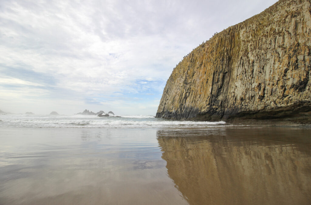
Mr Pelican and I had a nice truce that allowed me to sidle past him to watch the surf coming in over the rocks just offshore. The rocks were taking an absolute pounding from big old breakers.

There really is something mesmerizing about watching those waves crash up and over with a giant foamy, seething aftermath, and the water pouring out of crevices in the rock like a dozen tiny waterfalls.

As great of a start to the morning as it was, the best part of the Oregon Coast was still dead ahead. The four of us walked back to the car and continued our southward trek toward Florence. The next major landmark was only another 5 or so miles to the south – the town of Waldport at the mouth of the Alsea River. The Alsea Bay Bridge seemed pretty fancy-schmancy as we were crossing it, and Rich wanted to find a vantage point to look at it. Waldport was sort of like Newport in that the river/bay completed a northward bend shortly before reaching the bridge, so there was a spit of land isolated with a view directly to the west toward the bridge. However, unlike Newport, it took us quite some time driving down residential streets to actually find the viewpoint from a boat launch.

Sort of anticlimactic, but my dad likes bridges, so we went with it.
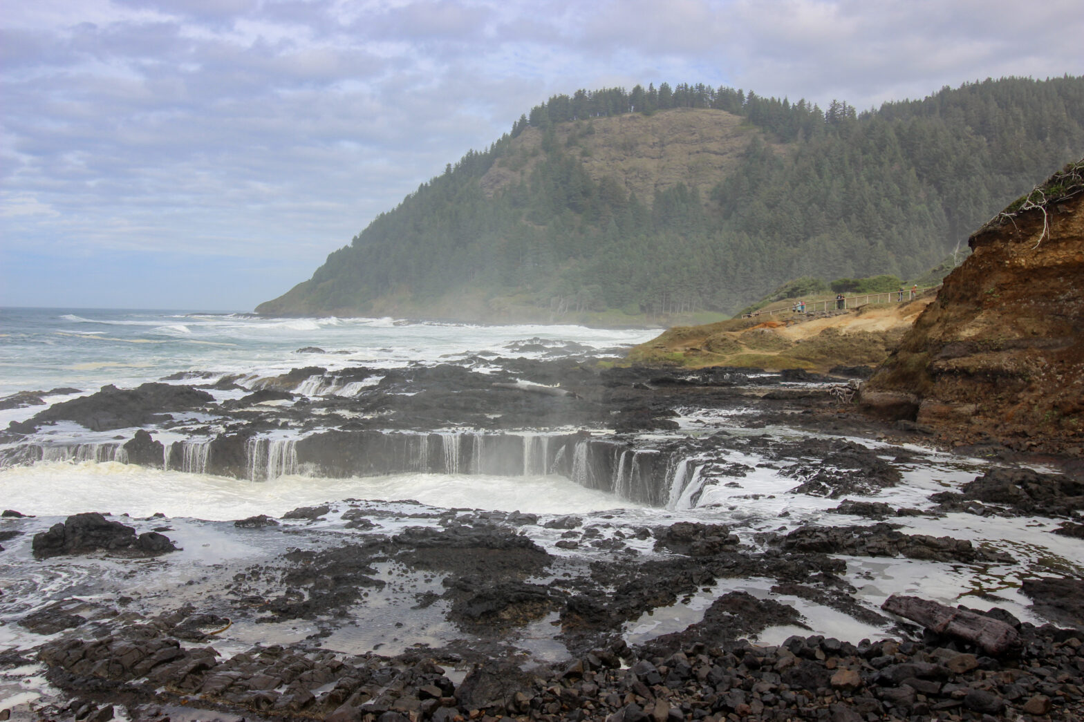
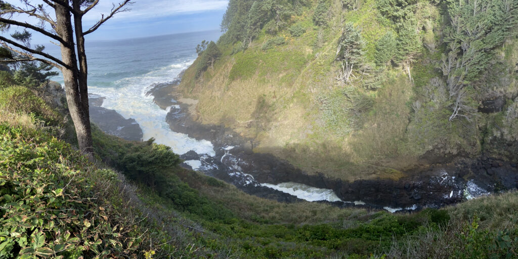
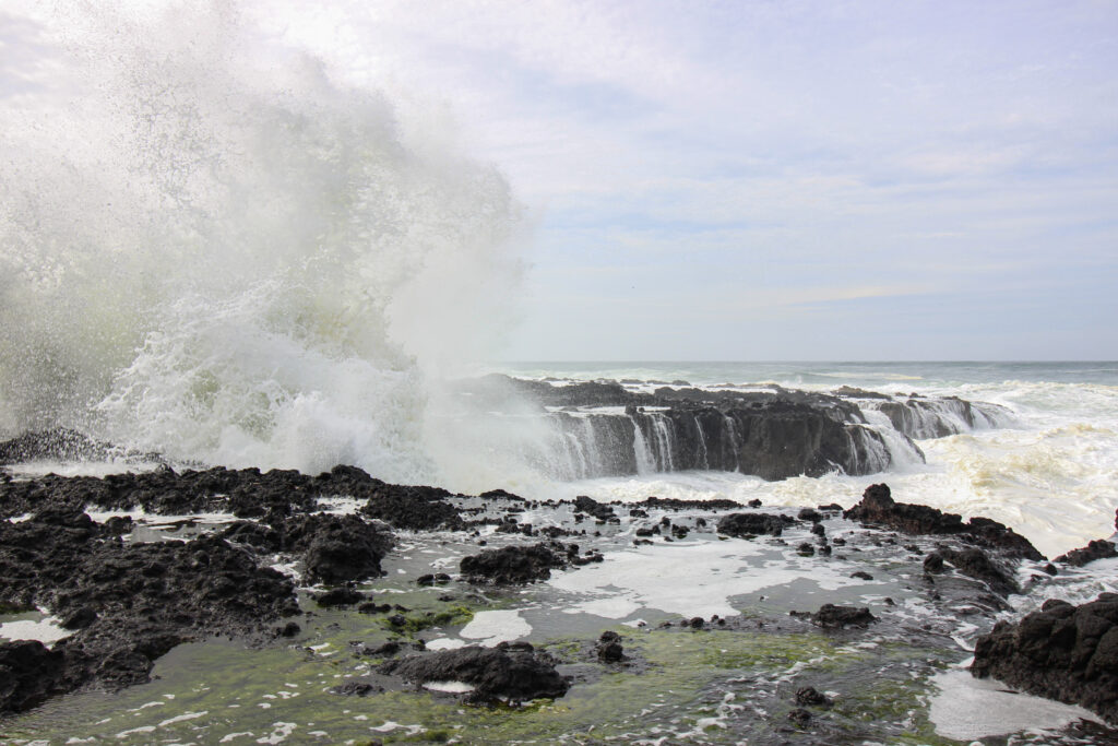
*Now* we were approaching what, pound for pound, was the coolest mile or so of maybe the entire Oregon Coast. After another 15 or 20 minutes of driving through a mix of pine forest, scrubby beach trees, and coastal tourist towns such as Yachats, the grade of the Oregon Coast Highway steadily increased – the ocean fell away as we climbed the side of a big old hill. This is the Cape Perpetua Area of the Siuslaw National Forest – an 800-foot tall hill with viewpoints and two of the more dramatic water features on the coast, Devil’s Churn and Thor’s Well.
Thor’s Well was first, coming immediately after a big uphill left-right in the highway. The parking lot was on a bluff far above the water, and if you looked way down to the right you got the chance to see the Churn.
It was a big, volcanic-black gash all the way at the bottom of the hill where water was able to rush way in as the tide came in. Even from up here, the sounds of waves crashing through each compartment of the Churn echoed like shotgun blasts.
My little-kid brain wanted to be closer to the action. Fortunately, there was a staircase that led right down to the edge of the water, though signs everywhere implored tourists not to get themselves killed by sneaker waves. The staircase itself had a cool view of the cape-and-cove, lit up in the hazy mist-shrouded morning sun.
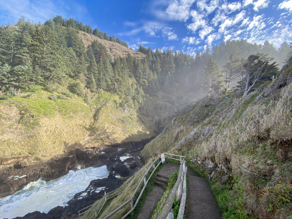
In spite of the visibility reduction, this made for one of the more spectacular views of our whole weekend.
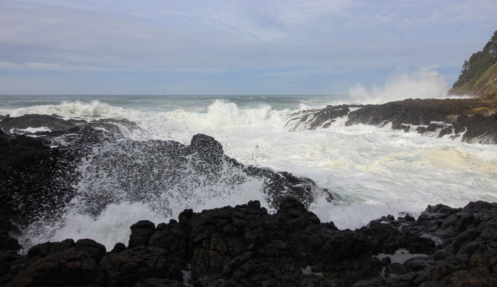
Down by the water level, I was unsurprised to discover that it was *so* much louder than it had been above. The water was just so powerful. I don’t know what it is about waves, shorelines, rivers, etc: water is just fun to watch. You didn’t even have to be that close to feel the power, though my dad wandered closer than I would have done so myself (Elizabeth was admonishing me as it was). They say a picture is worth a thousand words when it comes to descriptions.
But in this case, I think a video is worth 10,000:
That sums up the slow-motion chaos in all of its glory.
I think the four of us may have stayed down at the bottom of the hill for close to 15 minutes, enjoying the free show provided by nature. Finally, we made the steep switchback-y ascent back up to the car. I had myself a challenger against Drift Creek Falls for a favorite spot in Oregon.
Next up (and up was the operative word here) was the Cape Perpetua Lookout. It towered over the surrounding coastline, including the Devil’s Churn, and required taking a Forest Service Road up to a sharp fork in the road before getting on the road to the Lookout. Sitting in the passenger seat and munching on grapes, I could only be grateful that at least this road was paved unlike the one up to Drift Creek Falls.
The parking lot for the Cape Perpetua Overlook was shaded by some giant pines that dwarfed the scrubby little things you see by the water – I don’t know, maybe because of the elevation they can grow close to the water here but not closer to sea level? Maybe because of the soil? Either way, it evoked the same reaction as the ones near Drift Creek did the day before and the ones near Seattle had done back in January. I love giant cedars.
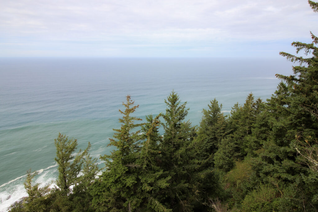
The views from the overlook were pretty grand.

And a short path took us to a gazebo overlooking the ocean.
The only downside was an annoying family inside the gazebo that really started to test Elizabeth’s patience by refusing to move. But she persevered without complaining out loud, for which I am proud of her. And we made it back to the car without incident.
The next stop was also mere yards down the road (within sight in the image above) at Thor’s Well, but before that, we were surprised and gratified to discover that the National Forest Service had actually put in a Visitor’s Center at Cape Perpetua. And it was a nice visitor’s center! While my parents and Elizabeth shopped for their souvenirs, I quickly found my preferred pin and enjoyed the exhibit on the lifecycle of giant trees within the Oregon rainforest. 7.5/10 visitor’s center, would recommend.
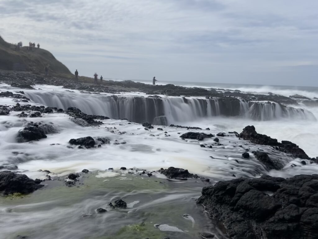
To finish off the trifecta of cool things in the Cape Perpetua Area, my dad drove a couple hundred yards to the next parking area in the south. This was the Thor’s Well area – Thor’s Well is a sinkhole-looking feature where all of the water from breaking waves seems to funnel into one spot. It’s best viewed right at high tide – coincidentally, right when we were there. If tidal pools weren’t in the picture, this would be a more than adequate consolation prize.
One immediately noticeable thing: the crowds here were thicker than everywhere else along the coast. Nowhere along the coast had been totally devoid of other sightseers, but things hadn’t gotten out of control anywhere. Even a quarter mile away at the Devil’s Churn, the four of us had been the only people to walk down to the rocky level. Here, the parking lot and walking paths were clogged with Little Piggies – parents with kids, annoying tourists, and ourselves (oh god, were we both of these?).
The Thor’s Well area had a little path that leads down to the two main attractions. The primary one is Thor’s Well itself, off to the right. And yeah – it was very cool. Waves came crashing in slow motion against the rocky coastline, kicking up spray and water and whatnot. That all drained slowly into a circular hole that was essentially functioning like a saltwater waterfall back into the ocean. Then as the waterfall into Thor’s Well began to slow down, another wave came crashing in to the shore and the whole process began all over again.

Please do not zoom in on the picture to see how many people I used AI to remove from it.
Speaking of those closer people… if they could get a little closer, why couldn’t I? Acknowledging Elizabeth’s shouted warnings to me to not get carted off into the Pacific by a sneaker wave, I edged down the trail and along the cliffside, staying as far away from the water as possible. The footing was kind of rough, but I was able to get to the north side of the Well without coming remotely close to getting wet. The waterfall effect was much louder and much more vibrant here.

Now, to wait for the right moment and get a shot of a big wave crashing into the Well…
Let’s see that view with iPhone motion blur!
And then, stepping in closer atop outcroppings above the seeping water, a video:
Now it was time to beat a retreat back to the paved path, where Elizabeth was waiting to chastise me for getting so close to the waves. That’s why we are great together: I get cool pictures, and she keeps me from dying while I get cool pictures. It works.
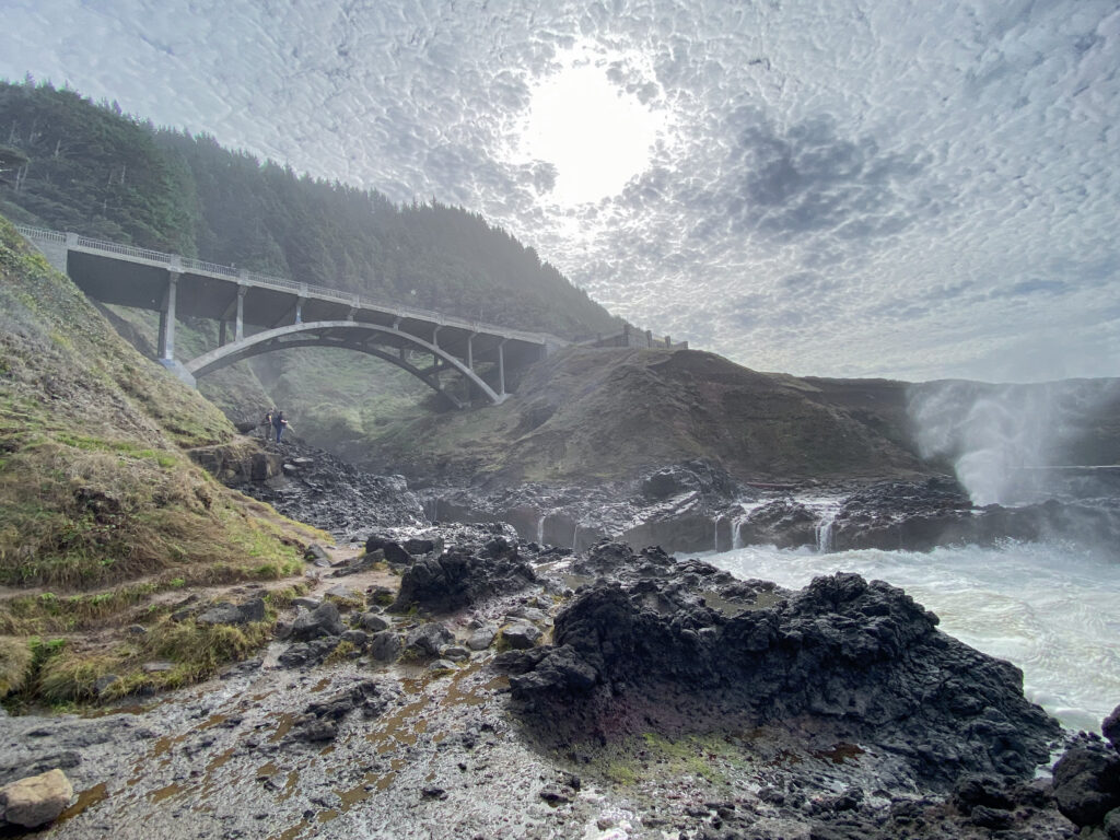
On the south side of the paved path is the Spouting Horn. It sits at the foot of Cook’s Chasm, a small gorge with a beautiful bridge (that Cande McCullough guy went crazy building the Oregon Coast Highway) spanning it. As the name implies, the Spouting Horn is fun because when a wave matriculates its way up the narrow mouth of the gorge, it enters a subterranean cave and forces its way directly up through the spout. The result is basically a saltwater geyser, right down to the whooshing noise as the water echoes through and out of the cave.
This was a Rich favorite, unsurprisingly.
In terms of sheer Wow factor within just a mile of road, I don’t think Cape Perpetua can be beat anywhere along the Oregon Coast Highway.
Although we were done with that exciting stretch, a half an hour of driving and some exciting stops still remained between us and our inland turn from Florence back to Eugene. Unfortunately for my dad, he’d fallen into the same classic blunder planning today’s itinerary that I had the day before (though in his defense, before Elizabeth and I had our flight canceled we were going to do his itinerary in reverse from south to north). The classic blunder was that no food option was available between here and Florence, and it was 12:30, and hunger levels were rising in the car. Tempers correspondingly began to lower, which is unfortunate because this stretch of highway also had some real gems: some cool bridges and beaches, the Heceta Head Lighthouse, and a big bluff with an elevator down to the water level where apparently you can pay to enter the Sea Lion Caves (guess what’s inside those caves?). For want of refueling, we decided to pass up on all of those and proceed to Florence. I was given the great honor of choosing the lunch spot, and for some reason I really felt like going to an A&W. How often do you even see a functioning A&W anymore? After eating the food, I sort of see why society felt as though it had progressed beyond the need for one. But it was still pretty cool to drink the root beer and see one of the remaining A&Ws in action.
There was one final stop on our coastal trip before it was time to head inland for our last night in Eugene. That was of course the site of one of America’s most historic moments: The Exploding Whale of Florence. For those unfamiliar with the story, the exploding whale occurred in November of 1970, as a dead sperm whale washed up on the beach near Florence. It became stinky very quickly, so the Oregon State Highway Division pondered how to get rid of the whale. They lit on the genius idea of putting a half ton of dynamite into the whale and blowing it to smithereens. This of course led to the spectacle of onlookers crying out in horror as chunks of rotted whale were thrown hundreds of yards. It’s one of the highlights of human history.
To my disappointment, the Exploding Whale Memorial Park doesn’t have any plaques marking the spot of the explosion – it’s too far inland on the mouth of the Siuslaw River. Nor did it have pictures, narratives, or perhaps a sculpture memorializing the fine deed. It had some riverfront:

It had some benches, and it had a cute little sign at the entrance.

Otherwise, it was a miserable flop.
Downtown Florence was better. We went there in search of exploding whale gear for Rich, Elizabeth and myself to buy. At first, the cute little gift shops downtown failed to provide what we needed, but near the end of the shops on Bay Street we found a t-shirt store headed by a sweet old lady that had exactly what we were looking for. Plus, the extended search had taken us through some other neat little gift stores, and it left us by a sign showing the distance and direction to the other Florence’s of the world – Alabama, Mississippi, Italy, Nova Scotia… The t-shirt shop was also right by an ice cream shop, and although the day was a little chilly for ice cream, the sun was out and it would have been a waste to not enjoy some by the water.

There was just enough time for one last trip to say good-bye to the Pacific Ocean out at the North Jetty Beach. This was accessed via a surprisingly winding road to a parking lot, then a trek across a couple of sand dunes out to the water. Although there were also no exploding whale markers here, it was a nice way to cap off an amazing weekend on the coast. I was already missing my parents and hadn’t even left them yet – in a weird way, this is one of the best signs of a great vacation that you can have.

With that said, our trip wasn’t *quite* done. There were still about 16 hours to before saying good-bye to my parents the next morning at the Eugene Airport. Normally I’d run that out into its own blog post, but there wasn’t a whole lot of detail, so I’ll just catch the quick highlights below.
The drive from Florence to Eugene was about an hour and a half up and down an twisty mountain road up the valley of the Siuslaw River and over the Coast Range, down into the Willamette Valley. While not full of the broad vistas that you get in the Rockies, I’ve found myself to remember our Coast Range experiences from the weekend fondly – rainforest and low mountains are a nice combo.
Once into Eugene, we made a stop at Fred Meyer (no, not that Fred Meijer) grocery store to pick up a six-pack of beer for Sam (turns out he didn’t like the one we got. It’s still sitting in Elizabeth and my fridge, three months later, as I finish up this blog) from his uncle’s brewery, Deschute’s. Fred Meyer is almost as cool as the regular Meyer, but a little too chaotic – which is too bad, because if I recall correctly, there was a fully functioning bar within the store. I’d love to go to the Fred Meyer with Elizabeth and drink a beer before we picked up the dog food or something. Outside of the Fred Meyer, we were all traumatized by the sight of the largest spider in the whole goddang world on the grill of someone else’s car. Maaaaaybe the Pacific Northwest actually isn’t the place for me, after all.
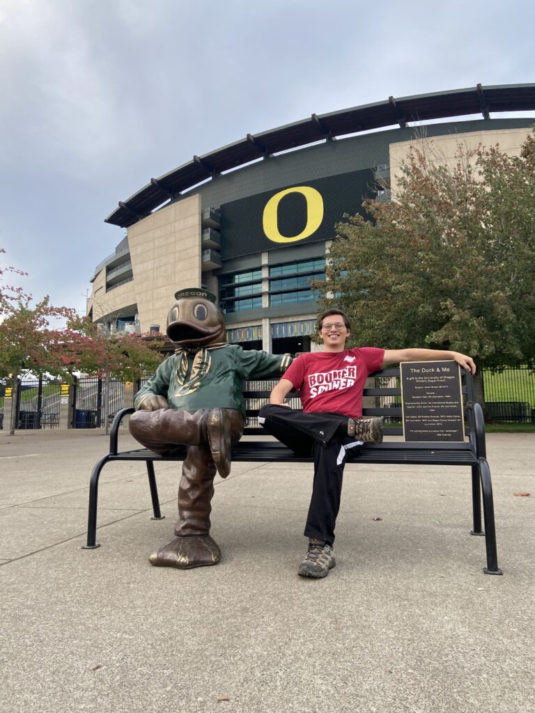
There was just enough daylight left on this October evening to drive around the University of Oregon’s campus for a few minutes in search of Autzen Stadium. And there was juuuuust enough daylight after that for me to get a picture with a statue of the Duck:
Funny enough, my coworker Max would be in Oregon for a Ducks game against USC in just a couple of weeks. He said it was really fun (and in fact used our itinerary to drive down the coast from Portland, which he said he enjoyed).
Dinner was sort of an ordeal. We all agreed that Mexican food sounded good, but the first restaurant that I found was too sketchy for my mom’s taste (it looked and smelled delicious, but it was a hole-in-the-wall type of place). The actual restaurant we ate at has been lost to time by my memory, but it was decent. If my parents or Elizabeth remember the name of the restaurant, I’ll add it in here and give the restaurant their due for B-caliber food.
And that pretty much brings us to the Tru by Hilton, where all four of us got another exhausted night of sleep in preparation for early morning flights. All four of us were on the same plane to Denver, although Elizabeth and I had a *much* worse boarding position (I ended up sitting with my parents with Elizabeth sitting close by). There were quite a few mountains to stare at on the way to Denver. From there, we split up, with my parents returning to Grand Rapids, and Elizabeth and myself making our way back into OKC on Monday afternoon, just a few days removed from our failed-Thursday-afternoon-turned-Friday-morning flight. As always, it was sad to wind up a trip, but it was nice to see Scipio again.
This was a first time in Oregon for all four of us. As a “backup” plan for Crater Lake, I can’t complain one bit about the Oregon coast. It had all of the cragginess, waterfalls, beaches, and mountains that one could want. I can’t complain one bit about getting to spend a long weekend with my parents either. The longer you’re away from home, the more you come to cherish those moments. Hopefully we get another chance to do something similar soon – maybe the California coast?