
Here’s the thing about long weekend trips: they’re actually quite short. This is especially true when you worked until 11:00 on Friday night, and then you flew two time zones away on Saturday morning. All of a sudden, you have a long Saturday afternoon, and then a fun early Sunday, and then you’re out of gas Sunday afternoon, and then it’s Sunday night and you’re eating like 20 scoops of ice cream with your fiancee and it’s already almost time to go back home.
It sort of seemed weird to me even with how short our visit was that outside of Blake Island, Elizabeth and I hadn’t seen any of what many people say is the most beautiful state in the Lower 48. Fortunately, I have a buddy up in Spokane who mentioned a waterfall less than 45 minutes away right along I-80 – Snoqualmie Falls. If we had a late morning flight back to OKC like we did, then there would be just enough time for four very enterprising people to get out to Snoqualmie Falls in the morning. Surprisingly, Michael and Irene balked at the idea a lot less than I imagined. Instead of dragging their feet when I knocked on their door the next morning to make sure they were ready to go, they were up and almost clear for the day. Michael had even cancelled his morning meeting to give us a little more time. In fact, Elizabeth was actually going to be the slowest one out of the gate. In an abstract way, I watched by their commitment to letting us see some of Washington’s beauty, although the two of then had never been to Snoqualmie themselves.
I-90 near Seattle is an interesting highway. It begins along I-5 directly downtown in an urban landscape. Within a few minutes, the highway crosses a lake and enters a more suburban environment, with row upon row of homes among big pines. No more than a few minutes after that, you pass by another lake on the left that is strewn with what look like vacation homes for rich people in the summer. And then, in literally like 15 minutes, you’ve left downtown Seattle and entered the mountain exurbs. It’s not like Denver where you instantly start climbing into the heart of the Front Range once you’ve left the High Plains, but the big trees grew right alongside I-90 and the road generally sloped upwards into the sunrise.
I’m not sure if we missed our exit for Snoqualmie Falls, but it took a several-minute journey along the placid Snoqualmie River through the town of – you guessed it – Snoqualmie – to get to our destination. Right at the very end of the drive, the road crossed a railroad trestle bridge, which just added to the joy of this Monday morning for me.
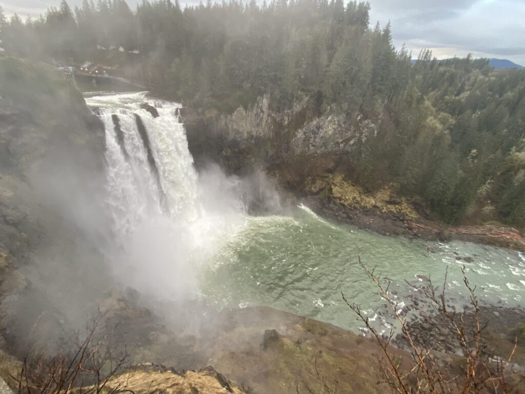
We parked in a free parking lot just across the road from the waterfall. There was a covered pedestrian bridge to cross it, covered with my favorite – historical placards. They outlined the history of the falls from the Snoqualmie people (ohhhh) to the present day, where the Falls are used as a major source of hydroelectric power by Puget Sound Energy. Sometimes it’s nice to have a little bit of context. On the other side, a little walkway led up to an overlook of the Falls. I won’t say it was a no-frills set-up – there was a gift shop, and plenty of parking, and even a hoity-toity hotel right on the brink of the falls a little upstream of the overlook on the near bank. But it also wasn’t a Niagara-Falls-style assault on your senses. There were big pines trees all around. It was a cool, mostly cloudy morning, very quintessentially Pacific Northwest – it was easy to envision myself as a local in this charmed environment.
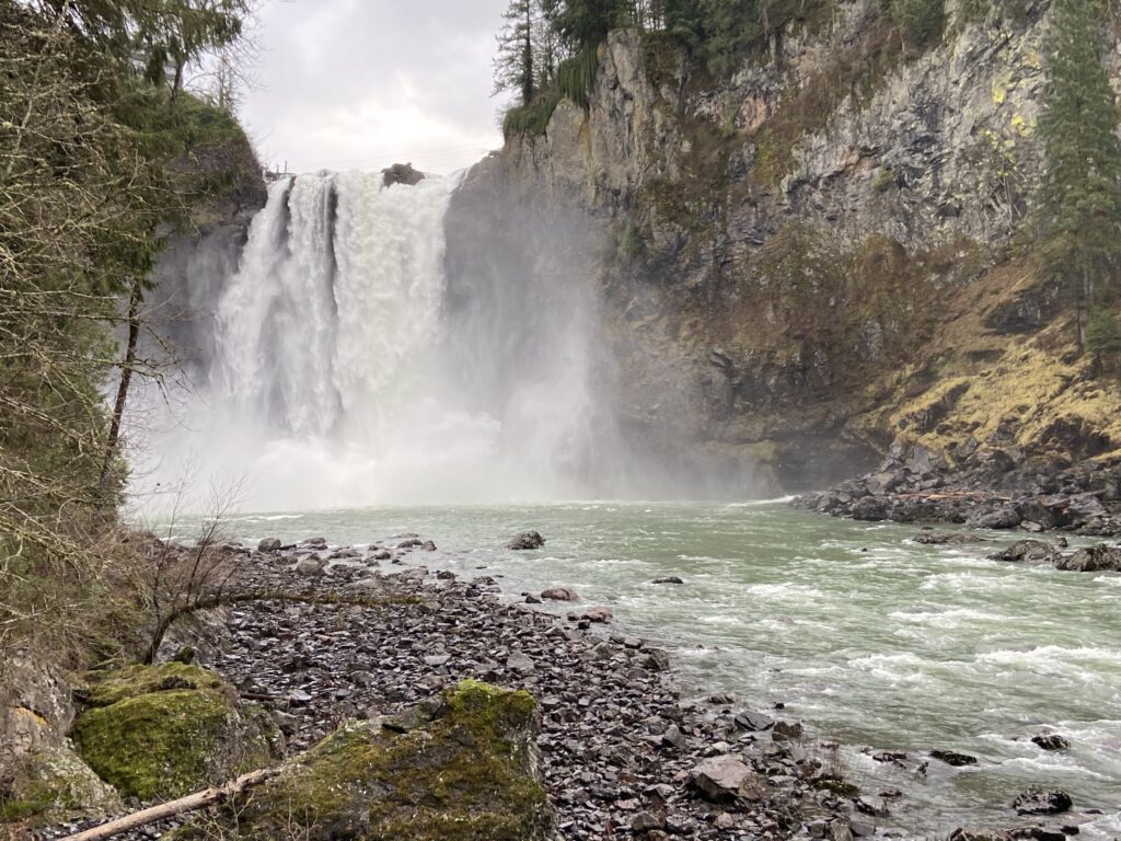
You could hear the Falls in the moment before we popped up to the overlook and saw it. Waterfalls have that very distinctive roar – a low, constant rush of water until you really tune your ear in. Then you can hear it ebb and flow in little waves. Same thing with the waterfall itself – Snoqualmie is large enough that the riverflow itself gets atomized into a large spray of mist well before reaching the ground, but you can still see individual surges of water remain intact well below that point until it all disappears into the churning, frothing base of the river below. That was all stuff I noticed after the first few minutes. At first, my impression was: Wow, that’s a big waterfall. And: Wow, that water is green.
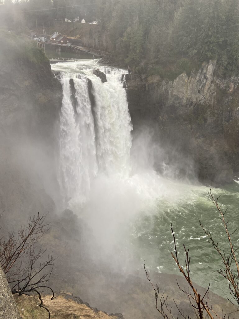
Apparently we were lucky to visit when we did. January is right in the peak of the Washington wet season, meaning the Snoqualmie River was running much higher than it does in the summer. Wikipedia says that then Puget Sound Energy diverts much of the flow for its hydroelectric generation, a use that I find both admirable as a conservationist and sad as a landscape enjoyer. I had no cause to complain as it was, outside of the persistent mist that coated my rain jacket at the overlook.
The thing about a waterfall is that after about 5 minutes of looking at a waterfall, you’ve looked at the waterfall and that’s all there is to see (exception: Grand Canyon of the Yellowstone). I really didn’t mind coming all the way out here for just a few minutes of enjoying the Falls and then driving back into the city – it sure beat the idea of just spending the morning in the city and then heading to the airport. But I also wasn’t disappointed when Michael pointed to a side trail that led along the right bank of the river from the observation trail before descending in a counterclockwise horseshoe northeastward and then westward to the bottom of the Falls. Snoqualmie Falls, if you can’t tell from my high-quality imagery, is about 270 feet tall. We were above the waterfall by a decent amount at the overlook. You can do the quick math on what that meant about the grade of the trail.
In fact, the trail itself was like our final ode to my first trip to the Pacific Northwest. PSE had done a great job locating it. The trail wound down through ferns, past bushes that signs proudly declared to be wild huckleberry bushes, and around giant red cedars extending impossibly straight up into the sky given the slope they were on. It was a beautiful 10 or 15 minutes, as well as a slick 10 or 15 minutes – rainwater made the trail a constant “don’t keel over forward challenge”. I also want to shout out a few other signs besides the nature ones along the trail. Puget Sound Energy also had occasional signs alongside the drainage areas, intake pipes, and up at the overlook where you can see the outflow from the power plant. They all extolled the virtues of PSE, the most environmentally conscious, affordable method of delivering power the world has ever been blessed with (paraphrase). I don’t plan on owning a business ever, but if I do, I will ask PSE who wrote those signs for them, because I want my propaganda to be just as good.
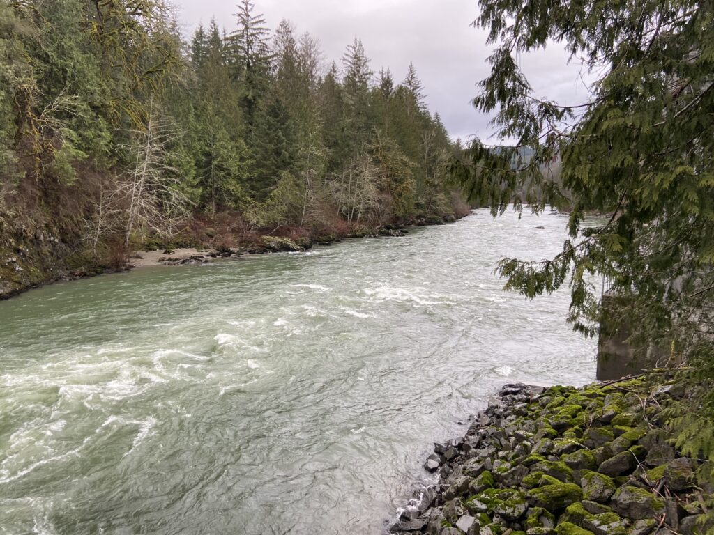
Down at the bottom of the trail, things leveled off along a boardwalk that crossed past some sensitive-looking power plant building thingies. Then it continued along to the riverbank, where I got to see the Snoqualmie River away a bit from the hubbub of the Falls. The river looked cold – probably an astute observation since the water comes from the heart of the Cascades. It also still looked pretty green, but who knows what that means. Finally, it looked like a damn fun river for rafting.
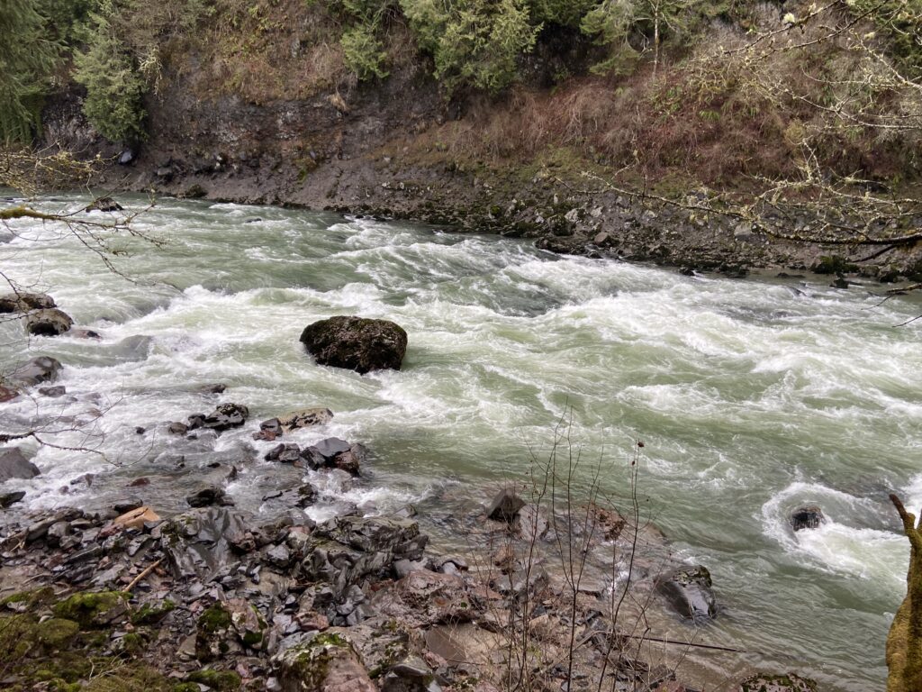
Snoqualmie Falls was even louder down here than it was up at the overlook. The mist had made it impossible to see what happened to that solid mass of water after it disappeared over the precipice from above. Now I stared into an inhospitable space where 3,000 cubic feet of water (minus however much gets diverted) crashed down onto the rock from 270 feet up every second. It got everywhere – onto the cliff walls, rising as mist up into the viewing platform, all over me down on the riverbank. There were big, wild waves in the shallow water as well. Not sure I’d be willing to go over the Falls in a barrel.
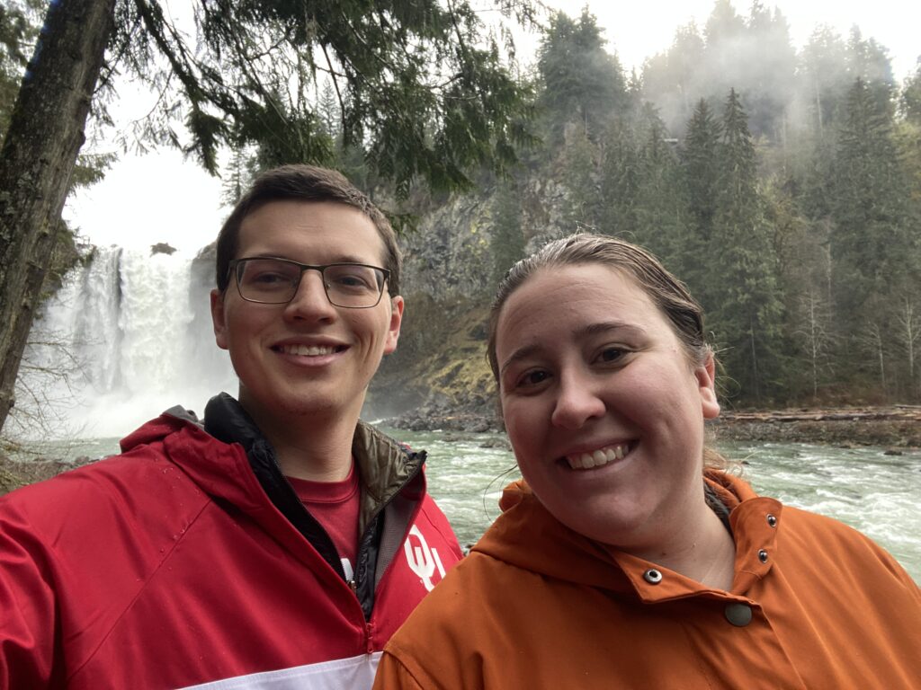
After getting a picture with the four of us + Oakley, we turned around to make the slick trek back up to the car. Along the way, someone sent a picture of Snoqualmie Falls in the group chat we’d made specifically for the weekend. That prompted Chris to reply, asking why he and Chanelle hadn’t been invited. Oh, right. Why hadn’t we invited them? Please consider this my official apology on behalf of Elizabeth and me. We should have done so.
It was a mildly strenuous walk up to the car. Elizabeth strapped Oakley’s leash around her waist and used him as a sled dog, eagerly pulling her uphill. The rest of us had to rely on our good old-fashioned leg muscles. It took 10 or 15 minutes, but then we were back up at the plaza at the top and could take the bridge back to the car.
I was feeling introspective on the way back into Seattle. The land had been beautiful to see, even though we had only barely edged into the Cascades. There’s a lot more to see in Washington, and I hope to get back soon. If Snoqualmie Falls filled me with that much joy, imagine what a week in the Olympic Peninsula would be like. Imagine!
Michael and Irene dropped us off at SeaTac with what seemed like plenty of time to get through security and get to our gate. Unfortunately, I played it too cute and tried to go halfway across the airport to the checkpoint with the shortest line. Then I got flustered when that line was long. Then I left my AirPods in the bin that they went through security in, and by the time I alerted security (3o seconds later) they were gone forever. Not a fond memory, but at least it finally prompted me to figure out TSA precheck with my NOAA ID card. Elizabeth would consider that a win, I’m sure.
The flight home was pretty front-loaded with excitement. After no more than 20 minutes, we flew over an absolutely MASSIVE peak that reached almost all the way to cruising altitude. It must have been Mount Rainier or Adams, though I’ll never know which for sure. I had a middle seat so we couldn’t even get an easy picture of it, but that was the coolest thing I’ve ever seen from an airplane, all lit up and snow-capped in the winter sun.
We arrived back in Oklahoma City a long flight later, where it was in the mid-70s with a breeze and dust in the sky. Welcome back to the Plains, indeed.