Michael Scott and Rascal Flatts put it best: “Life is a Highway”. And if that’s true, then there’s no highway I want to ride more than the Pacific Coast Highway. The PCH runs for 656 miles across the state of California from Orange County up to the northern part of the state. It’s a famous route – when you think of those sunny drives with the Pacific sparkling just off to the side of the road, that’s the PCH. And it just so happens that the PCH is a major thoroughfare into San Francisco itself. It’s not the most direct route from Pinnacles National Park into SFO, but if you’re an Elizabeth you can usually wheedle Nolan into taking detours of this length.
Before we left the national park, the three of us made a quick stop at the Visitor’s Center for some souvenirs. I found a really nice little pin to go on my board, and we found a phenomenal coaster for our coffee table, and Elizabeth found an insanely overpriced magnet for her collection. She also got an ice cream bar. Elizabeth knows how to live in luxury on hot California days. I decided to hold out for some In n Out or ice cream along our drive to San Fran. Big mistake, it turned out.
The drive back out of Pinnacles was sublime. Fields of black mustard dotted the landscape, with grass still holding on to a lot of that springtime green.

For a while, the terrain was a beautiful ruggedness as we drove north between two of the Coastal Range spines. After a while, vineyards started to replace scrub brush and mustard as the dominant sight.
Once we’d gotten around the north side of the ridgeline that had dominated the left side of the road, the terrain broadened out into a broad, flat valley. For the first time, I was beginning to understand why California seemed like heaven to people all those years ago. There were the Diablos ahead and to the right, another range straight ahead, and the Gabilan Mountains behind and to our left, culminating in the 3,400-foot Fremont Peak. Lettuces, grapes, strawberries – you name it, the valley we were in was growing it. And all of this on a bright, sunny California day. Our moods had been dampened by the length of the Pinnacles hike, but fueled by Target snacks from the night before they quickly soared again.
Apple Navigation had a very unique way of cutting us west-northwest toward the coast and the PCH. It sort of makes sense, since we had to get across a mountain pass, but it was sort of a weird exurban blend of county highways and other secondary roads that led us toward the town where we’d pick the highway up. Elizabeth drove through the outskirts of the little towns of San Juan Bautista and Watsonville, then turned right onto an on-ramp. This moment was burned into my memory. It was a sunny late spring day without a cloud in the sky, and there was nothing but open road in front of us on California 1. What a way to enter the Pacific Coast Highway.
The Monterey Bay sparkled in the mid-afternoon sunlight when we were able to get glimpses of it. For the first twenty minutes or so, it was more beach-town-y than anything else as Elizabeth had to matriculate the Santa Cruz area. Contrary to my expectation that everything in California would have an overgrown veneer of San-Diego-ness to it, Santa Cruz actually seems like a bit of a small town – albeit an overcrowded one in the vein of some eastern beach towns.
But then we were out (with no ice cream for me – a mistake, as I would quickly realize). I had an online guide to the PCH between Santa Cruz and San Francisco to work from to tell Elizabeth where to stop. California Gurls blasted through our rental’s sound system as I led her to the first of the famed stops along the way, Shark Tooth Cove. All the while, I was keeping an eye out for my shot of a hill of wildflowers splashed by the afternoon sun. So many hills had some flowers, but there were no perfect foregrounds.
Parking at Shark Tooth Cove was a bit of a nightmare. Once again, the whole holiday weekend thing was clearly working against us. There was parking along the side of the highway, but it was a madhouse of cars entering and exiting, all while through traffic tried to get – you know – through. But if you judge an attraction by the amount of excitement it generates, we were definitely in the right spot.
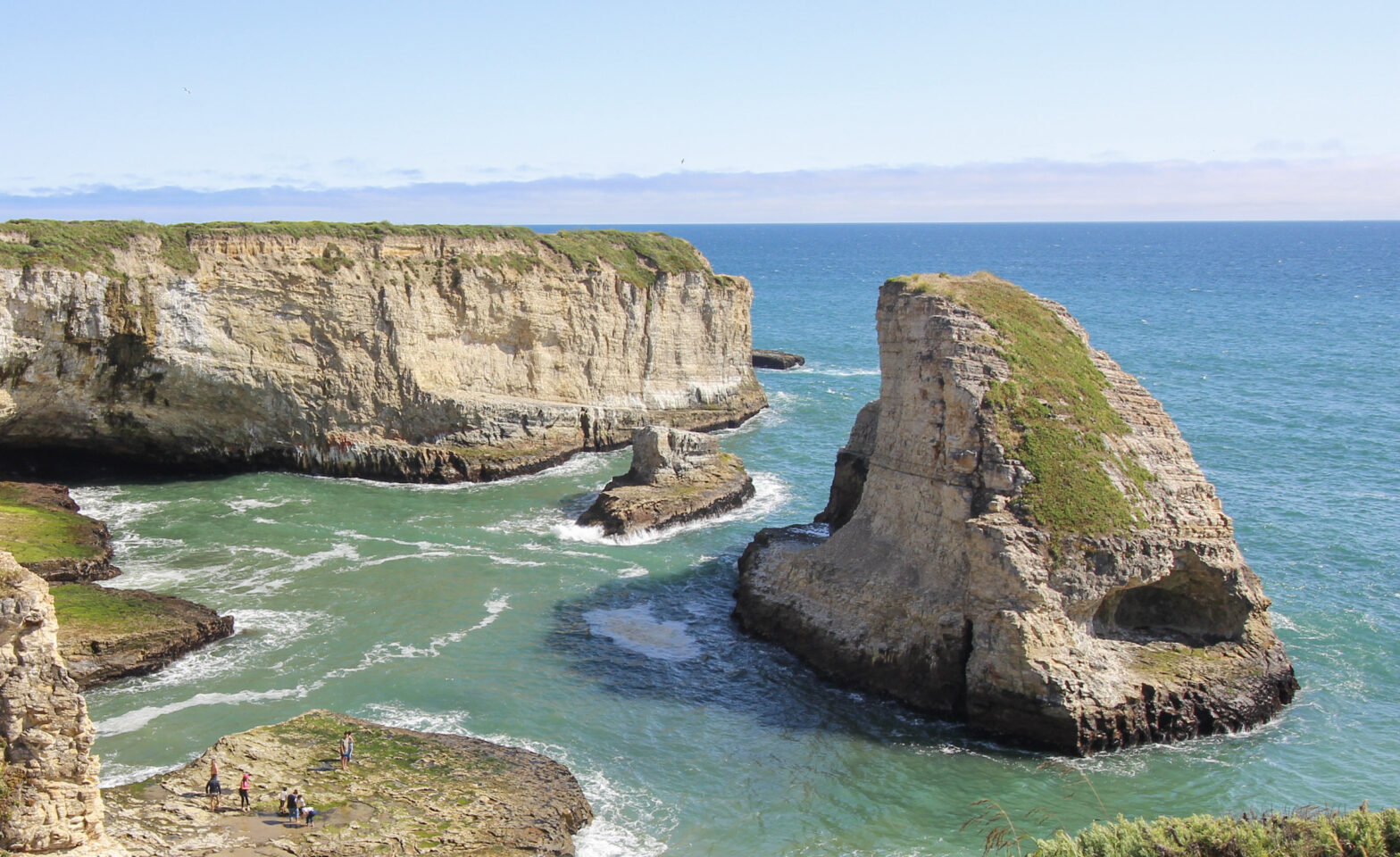
The walk to see the Shark Tooth was no more than a couple hundred feet across an abandoned railroad track. There amongst the throngs of little piggies it lay in the Pacific:
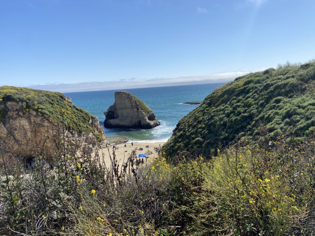
Acting on a hunch, I led Elizabeth and Stephen up the right side of the cove to get a better angle. Here’s a real banger of a wall hanger.

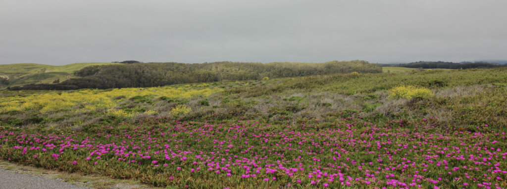
Ok, we just had to make sure we were staying on time to keep our reservation that night at Fisherman’s Wharf. This was a 1000% worthwhile quick stop, but we couldn’t keep stopping everywhere. So we went another couple of miles north with Something About the Sunshine blasting to the incredibly aptly named Cliffs Beach. It wasn’t the foreground that I was expecting, but technically, this was a hillside covered in blooming flowers…
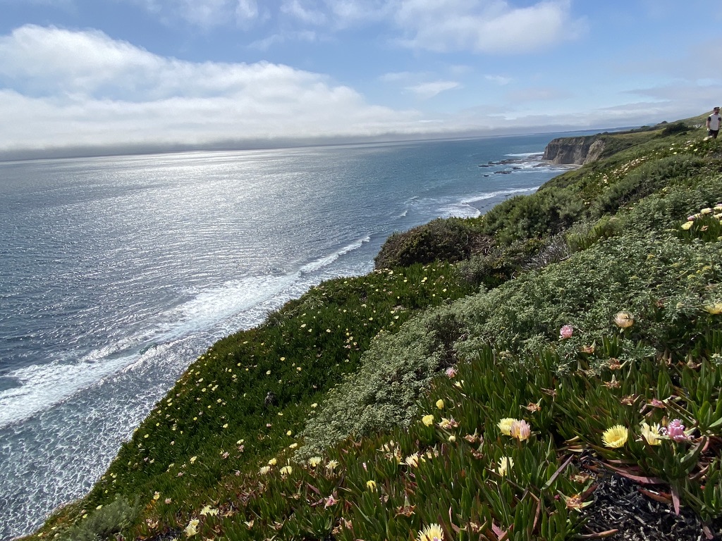

Another candidate arguably very suitable for framing, in my biased opinion.
While I was living my California Coast dream, dark clouds were building on the horizon. Literally. You can see them in both shots. The marine layer (June gloom, baby!) was holding strong north of Monterey Bay. Elizabeth drove a few more miles and we entered it. What had been a chilly but sunny afternoon all of a sudden turned into the dread nightmare of every California resident – a (gasp!) non-perfect weather day.
Not that I minded. It was Memorial Day weekend and the specter of a long, hot Oklahoma summer was looming in my mind. If the California coast wanted to spit 56 degrees, breezy, and drizzle at me, I was open to the experience. We kept driving north into the gloom, heading for the spot my parents had recommended highest on the drive. Typical of my parents, this spot was a lighthouse: Pigeon Point Light Station. Along the way, we drove past forests of redwoods, big bluffs, and estuary creeks leading into the ocean. It made for some neat geography.
At Pigeon Point, Elizabeth and I first stopped to use a restroom. Stephen’s jeans suddenly seemed smart compared to my lack of pants and light jacket in the face of truly chilly conditions.
The lighthouse was… a lighthouse. I know that’s the sort of thing people love, but for me this didn’t hold a candle to our previous two stops. Not sure how much of that was due to the weather, or the excitement of the first two stops being ON THE PACIFIC COAST HIGHWAY, and how much of it is just me enjoying natural scenes more than I enjoy lighthouses. It’s probably a combination of the two. Anyways, enjoy the lighthouse.

Personally, I found myself enjoying the flowers overlooking the ocean much more, which probably says something about me as a person.
The last thing I wanted to do was dawdle, because it was already 5:00 and I could tell that Stephen (a consummate non-complainer) was starting to get pretty darn hungry. Besides, now that the whole day had turned chilly, the “Americana West Coast Dream” vibes of the drive had worn off a bit. We passed through some small towns that looked like they’d be quite cute, but not worthy of stops given the circumstance. I did get my “field of flowers” shot, but the moody lighting sort of ruined the California vibes I was going for.
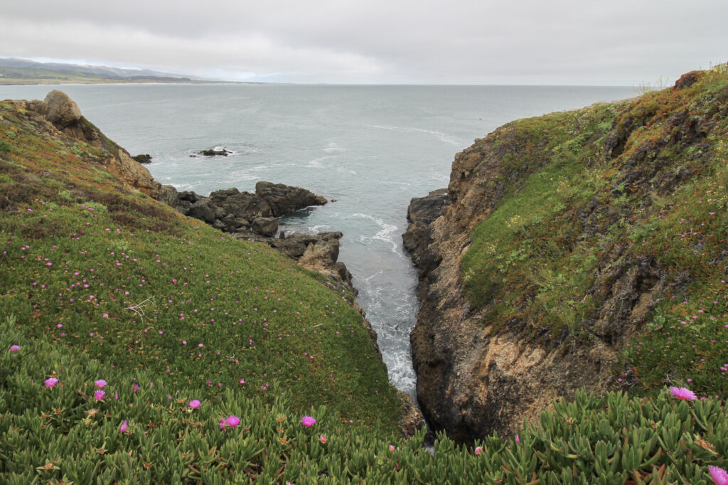
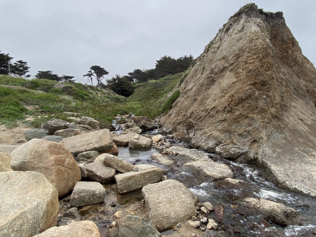
And so it was that we ended up driving all the way up to the other side of Half Moon Bay, right before the outer reaches of the Bay Area sprawl. There was a marine reserve tucked in on the northern edge of the bay in the town of Moss Beach. The promise of seals at the marine reserve was enough to get the three of us pulling down side streets in town and parking along a creek (San Vincente! California loves their Sans) right at the edge of the beach. There was a little boardwalk right down to the water.
And it was here that I got my only (lighthouse maybe excluded) disappointment of the Pacific Coast Highway. The beach was CLOSED to the public beyond a certain point – the point where the seals were. It’s like having a stadium in your town but not allowing any sporting events to be played in it. Why even have the beach?
It was still cool enough. Those who know me well will know that my disappointment was assuaged by the sight of San Vincente Creek tumbling (and yes, it did tumble a little bit) down toward the surf. There’s nothing I love more than the mouth of a good body of water.

After giving me a minute or two to splash in the surf and touch the Pacific Ocean, we had to move on. There was still another hour of driving that had to be done to get us to downtown San Francisco for the night, and Stephen and I were both ravenously hungry. I had a reservation right at sunset at a restaurant (Fog Harbor Fish House) that would let us see the sun go behind the Golden Gate Bridge. Or it would have, if I hadn’t forgotten about the existence of June gloom. Instead, the three of us got to eat a fancy dinner much later than we’d wanted while we were so bone-tired from hiking and driving that I nearly fell asleep in the Uber on the way back to the hotel.
But if you aren’t that tired when you’re traveling, doesn’t that just mean you wasted an opportunity to see a new part of the world?
I want to drive more of the Pacific Coast Highway someday (add it to the endless list of vacations Elizabeth and I have on our docket). The stretch we saw was so quintessentially West Coast, and I genuinely loved it. Great call rerouting us, Elizabeth.