If you ask 100 people in the United States where the Flint Hills are, I’d be shocked if more than a couple of them could point to eastern Kansas. They’re a narrow range of hilly, rolling terrain aligned from north central Oklahoma into northeast Kansas. Due to the rocky nature of the ground, the Flint Hills weren’t converted to large-scale agriculture unlike the rest of the Great Plains, instead being used as rangeland. By consequence, the Flint Hills have some of the most pristine stretches of unbroken prairie remaining on the Great Plains east of the 100th meridian.
In other words, it’s paradise for a storm.
I’d never before had occasion to chase in the Flint Hills. It’s been quiet out there for the years that I’ve lived in Oklahoma, or there was a viable target closer to home when it wasn’t, or I was lazy. On 19 April 2023 circumstances came together to let me chase the Flint Hills for the first time in my life. It’ll be an experience that I never, ever forget.
The first and foremost circumstance: I was already roughly up in the area. From 17-21 April I was in Kansas City for the NWS New Hire Course based at the NWS Training Center. A brief sidebar: this was a very, very fun week. It always makes me sad that I can’t really blog about “minor” trips and life events like New Hire without completely drowning myself in blogging work, because weeks like that are the ones I truly want to remember down the road. The course brings together new NWS employees from around the country to learn largely arcane information about the organization structure and take leadership development seminars over three very long workdays. The real fun happened after 5:00, when dozens of people were released to the Homewood Suites with a per diem, a social hour with free Bud Light on tap, and no other obligations for the evening. On Monday I met up with RAC friends upon arriving in town and we got dinner and drinks at a bar nearby called Nic and Nino’s. On Tuesday, I joined a massive group heading into Kansas City for BBQ (burnt ends are every bit as good as people say. KC brisket is overrated though). Wednesday, of course, was the famed karaoke night at Nic and Nino’s that everyone looks forward to.
But what if Wednesday instead was a day for a flare-up of my recurring penchant to interject storm chasing into my social life? Sure, it would be easy to just go drink $3.50 whiskey sours and belt out Miley Cyrus into a mic. In fact, it was probably the right thing to do when you consider network-building. But trust me, I didn’t skimp on network-building over the rest of the week. And conditions certainly looked intriguing across central Kansas that evening.
Conventional wisdom by the day of suggested there were two primary targets for storm chasers – near the vicinity of an occluded surface low in western Iowa, and along the dryline in central Oklahoma where the upper-level ascent would be strongest. I’m not a genius, but I thought there was a third target somewhere around I-70. The forcing should overspread a region where the dryline sort of arced northeastward toward the surface low region, and while convective mode wasn’t great there was a strong hint in some of the more convective-happy models as well as machine learning guidance for a tertiary tornado bulls-eye near or north of Topeka.
To chase or to go to karaoke? That was the question that myself and Dan Butler, a meteorologist I’ve known a while from NWS Spokane, had to grapple with. At first I leaned more toward chasing while he leaned hard away from it. This was further reinforced by the steadfast refusal of the HRRR (and really, most of the HREF) to support storms in our somewhat capped, somewhat mixed out Kansas dryline regime. That didn’t mean the CAMs were dead, though. About midday, they started lighting up the dryline right around the OKC metro like a Christmas tree. Of course this was happening during my week away from home.
As class began to wind down on Wednesday, a funny thing happened. First one run of the HRRR, then the next – they both lit up convection right around I-70 near Manhattan, and brought it into the region around Topeka and just north. We might be back in business. A quick analysis of observations told me what I needed to know – we weren’t tornado hunting today. It was far too mixed out in eastern Kansas, where dewpoints were in the upper 50s. But if the cap broke and a storm got going, the LLJ was going to start cranking right around 8:00. We just needed to wait for go-time showtime.
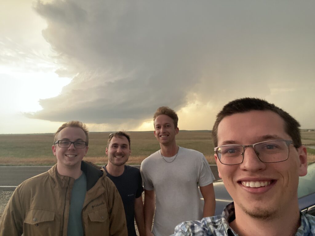
Even then, I wasn’t convinced until Dan asked me if we were gonna do this right as the class wound down. Well, if he was in, I was too. And if the two of us were in, Joe Worster, a meteorologist from NWS Tallahassee that I had just met this week, was in. And my CRV was parked at the hotel just a few hundred yards away. Along the walk back, we added a fourth to our crew – Stephen Baron from NWS Gray (Maine), whom I had met at RAC a few months prior.
The dream team was assembled (kind of. It took longer than I wanted to get everyone in the car). There was enough gas to make some headway down I-70. It was 5:00 but CI was just getting going down in Oklahoma and to our north along I-80 in eastern Nebraska. The CRV was buffeted by strong southerly gusts along I-70, with some weak HCRs trying to get going. This was a decent sign, if you were into that sort of thing. Along the way, I tried to get the measure of my partners on this chase. Stephen’s a quiet dude. I tried to pry some info out of him, and it became clear that not only had he never seen a tornado before, but he was also embarking on his first storm chase. On the flip side, Joe was positively bubbling with excitement. This is how I learned that he was a native Ohioan (of course), and that his major score in his life was Palmer, Iowa in 2022 (of course). Dan was affecting veteran storm chaser vibes as befitted a former Nebraska grad student.
The weather started making our chase difficult before we’d even gotten into Topeka. And not the weather here in Kansas – on the contrary, my steadfast belief in CI along the Kansas dryline was clearly going to come true. The first storm had gone up earlier on the northeast side of Wichita (good grief… so far…) within the dryline circulation, and was at least trying its best. I called James to ask him for an update. Poor guy had to be into his office for a mid shift that night, but he was already on the north side of town and shadowing the storm. It provided a potential southern option as moisture finally made its way up from Oklahoma with the LLJ towards sunset. Meanwhile, the I-70 dream seemed to be in play as well. An updraft was going up over Manhattan and looked pretty good from far-away radars. We had time to figure it out.
No, the problem wasn’t the weather in Kansas. It was back in Oklahoma, where the day was going from “probably a cap bust” to “maybe not a cap bust” to “maybe an LP supercell at sunset near OKC” to “oh crap there’s multiple storms going up at 4:00 pm in an insanely favorable environment”. I’d told Elizabeth to pack her “go bag” and get Scipio’s harness on about a half an hour before leaving, but she seemed stubbornly convinced that hail was her only concern. Now Elizabeth was changing her tune. In spite of her desire to not be distracted from packing for her bachelorette party the very next day, a supercell developing and moving up I-44 directly toward Newcastle will start changing your mind. A supercell with a big old hook echo aiming for either south Moore or north Norman will remove all doubt. Just as I was pulling into a Phillip’s 66 at the Topeka Service Area along I-70, Elizabeth was hustling Scipio into her car and searching for a vantage point along I-35 where she could watch and see if our house was going to be destroyed by the next great Norman-Moore tornado (didn’t we just have one two months ago???)
My desire to chase had already been on the marginal end – karaoke night *did* sound fun. Now it plummeted. I wished I was back in my hotel room, able to talk with Elizabeth. I wished I was back in Norman, to be honest. Nothing to do but switch drivers with Joe and call her and hope I wasn’t lying when I said the storm was going to go just north of our house. Before we switched, I suggested staying put where we were so we could keep the Manhattan and Wichita storms in play. But I was overruled by Joe and Dan, who wanted to not lose the Manhattan storm. They started charting a course to US-75 while I sat in the backseat, barely paying attention.
It gradually became clear that although Elizabeth and Scipio were shaken from the experience, we were just barely gonna be okay. At one point, she screamed over speaker phone and I thought that this was the moment The Big One had started. But the storm never managed to plant. There was another supercell coming up behind it, and I told her to be ready to execute an exit plan to the north. This time, she was convinced the supercell’s meso would stay to her south, although I was concerned about an occlusion. Surely the hail would do a number on our house though.
Meanwhile… I looked back up and found us on a back road in the woods somehow, going 30 mph in search of a view. One look at the storm we were “chasing” told me that Joe and Dan had lost the plot. It was a goner. I checked radar and yeah. It was a goner. Not-so-silently cursing myself for not speaking up louder to wait in Topeka, I asked if I could start driving again. It was time to start taking a more active role in our chase.
We basically had two choices, bombing southward on US-75 back toward Topeka. We could either give up, go back, and make it in time for karaoke night at Nic and Nino’s, a little embarrassed but no worse for the wear. Or we could full send down the Kansas turnpike toward the vicinity of Emporia, where the original Wichita supercell was at least showing signs of sustaining himself. Dan was all for heading down that way. I called James again and asked him what he saw. His response was essentially “not much”. But looking aloft from the Topeka radar, Dan was convinced that the storm’s meso was cranking. I just had to trust that we needed to be in front of it for sunset magic.
To do so, we had to cross in front of several other rounds of convection along I-335. We had plenty of time to scoot south of this supercell before it reached the Emporia area – the bigger problem was the clock, which was becoming more of an enemy with each passing minute. The drive from Topeka to Emporia takes almost an hour even if you’re going a Very Responsible Speed like I was. Sunset isn’t super early by April 19, but it’s not like it was a 10:00 pm sunset with infinite twilight in Montana either. There was a practical limit to how long we could do this before it got dark. And worst of all, Dan reported that when we got to Emporia we’d have to probably go west to meet the storm a bit closer. Gritting my teeth, I worked through multiple rounds of construction, heading inexorably southwestward to the most distant core on the horizon.
A little bow echo was forming on the north side of the supercell, and the sun began to set behind the high-based convection in a blaze of orange glory. Stephen, sitting in the back right seat, had the best view and was clearly enraptured. He started snapping pictures through the window, which was both charming and reminded me how jaded I am after 7 years on the Plains – because I was just thinking about how those storms were absolute junk. Joe took that enthusiasm about as far as one could take it, and then maybe a step further besides. First of all, he rolled down the passenger window so that he could get a picture while I was driving a Very Responsible Speed down the interstate. Then he asked if we could pull off on the side. Of the interstate. To take pictures. I shot that idea down, but offered to pull off at the next exit so we could enjoy this sunset storm before heading back. But no – once again, Dan vetoed it, claiming our storm’s meso was absolutely cranking. I reluctantly deferred to him and continued driving south.
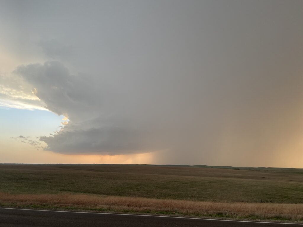
It was coming up on 8:00 by the time I pulled off of the interstate onto US-50 in Emporia. James, fearing being called in early for his mid, had turned around, leaving a last report that the base of the storm continued to be featureless except for one very small, brief lowering. However, he said the meso was obviously doing just fine as well. So we had that to work with. As I started going a Very Responsible Speed down US-50 to the west, the sun began to peak through the sheets of forward flank precip in front of me. It was a stark reminder that nature’s timer was counting down. But still, we were almost within contact of the storm. You’ll have to imagine the context of this, because I was driving and didn’t see radar, but it appeared that this road was going to spearhead right into the forward flank precipitation. That meant to the southwest I could see a strong-looking, golden-orange anvil. Between the anvil and the forward flank, there was what looked like the left side of the updraft. Privately, I thought it looked pretty strong, but it was still hazily obscured by precipitation. We needed to get west and south to get a better view.
Right after passing a cop, who either was too nice to pull me over despite my Very Responsible Speed or was busy storm spotting, my phone buzzed in my pocket. BEEEEEEEEEEP. BEEEEEEEP. What the hell? WEA? I had about 3 seconds to think “There’s no way that they issued a tornado warning” before my brain kicked into gear just as someone announced that it was for a severe warning for 3 inch hail. Oh, okay, that made sense. Wait…
“Am I driving into 3 inch hail?”
Dan assured me that there were options to stay away from the giant hail. There were a couple of south options – a dirt one in just a few miles and then a south road out of the town of Strong City a ways beyond that. I had him calculate a time of arrival for the giant hail into Strong City. Then I had him tell me how far we were. Then I ran the math in my head, and discovered that we were winning the race by bare minutes. Then I stopped going a Very Responsible Speed and focused on winning the race.
Giant raindrops were falling out of a peach-colored sky onto the CRV as I assiduously stayed in between construction cones and swerved onto Kansas-177. I’d won the race – for now – and it was time to get south and get a view. Even to this point, my thought was “hey, at least we got ourselves a supercell” – what was about to dramatically unfold over the next few minutes. We could check out the storm, which from my fuzzy view of the updraft should have a pretty sunset meso structure, and then we could come in behind the storm and look for some baseballs. Maybe it wasn’t the massive wedge that was currently ongoing near Cole, Oklahoma (I tried not to think about the fact that I was missing the first easily visible Oklahoma wedge since I’d moved there in SEVEN YEARS), but at least we wouldn’t be laughed out of karaoke night when we arrived. Some of the speculative comments from other meteorologists at New Hire when we’d left had me on edge about that.
Kansas-177 passed through the small town of Strong City (population 399), then it led through the slightly larger town of Cottonwood Falls just to its south. Yes, I’d clearly won the race against the giant hail. The drops faded away, as did every other manmade structure, tree, and any other obstruction to the horizon. Oh. *This* was the Flint Hills Scenic Byway.
Another couple of miles to the south, and I felt comfortable that we were safely out of the way of any softballs being pitched around the meso. There was a wide pull-off on the left side of the road. I backed my car into it so we could view the supercell distant on the west-southwest horizon.
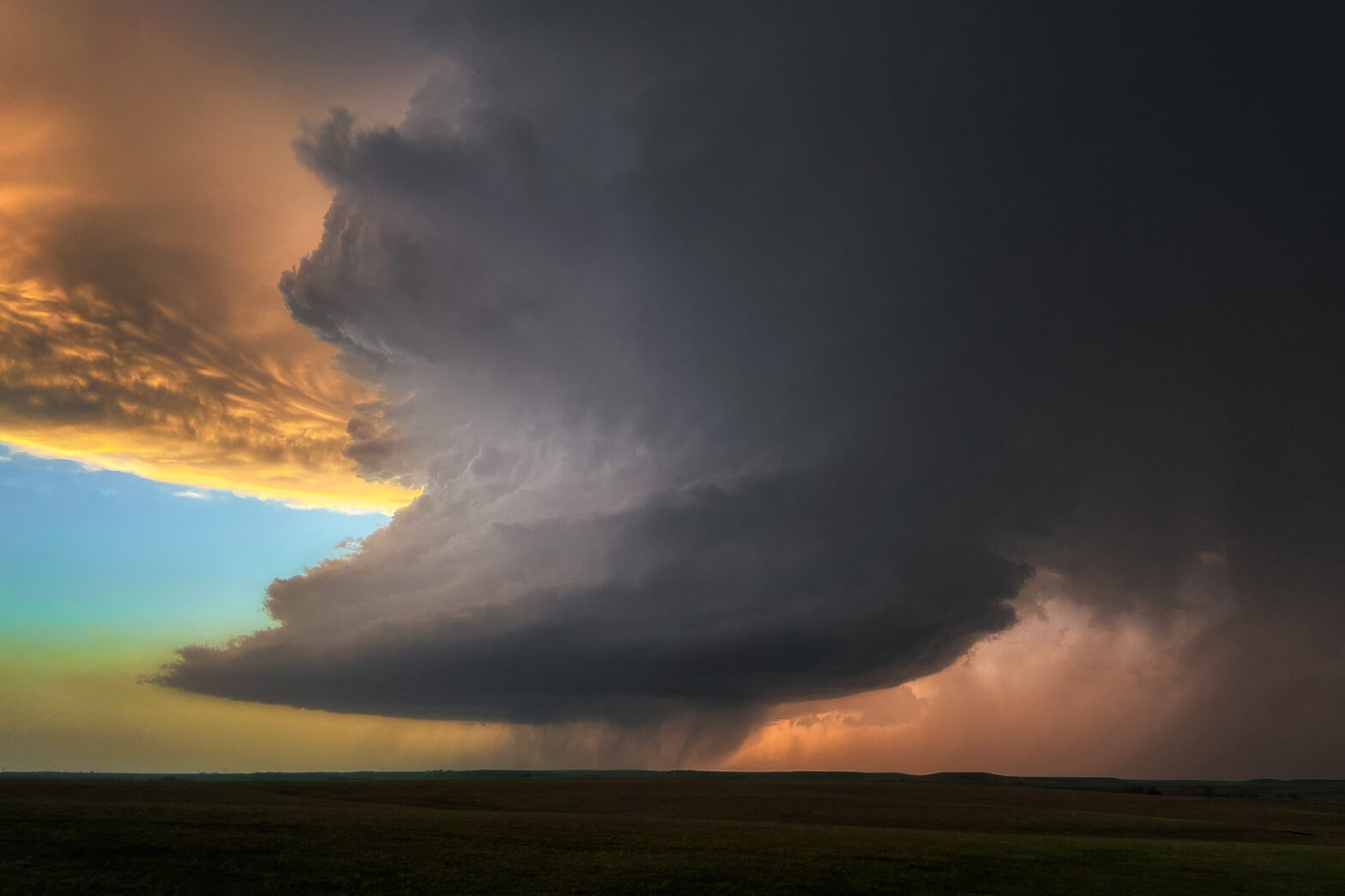
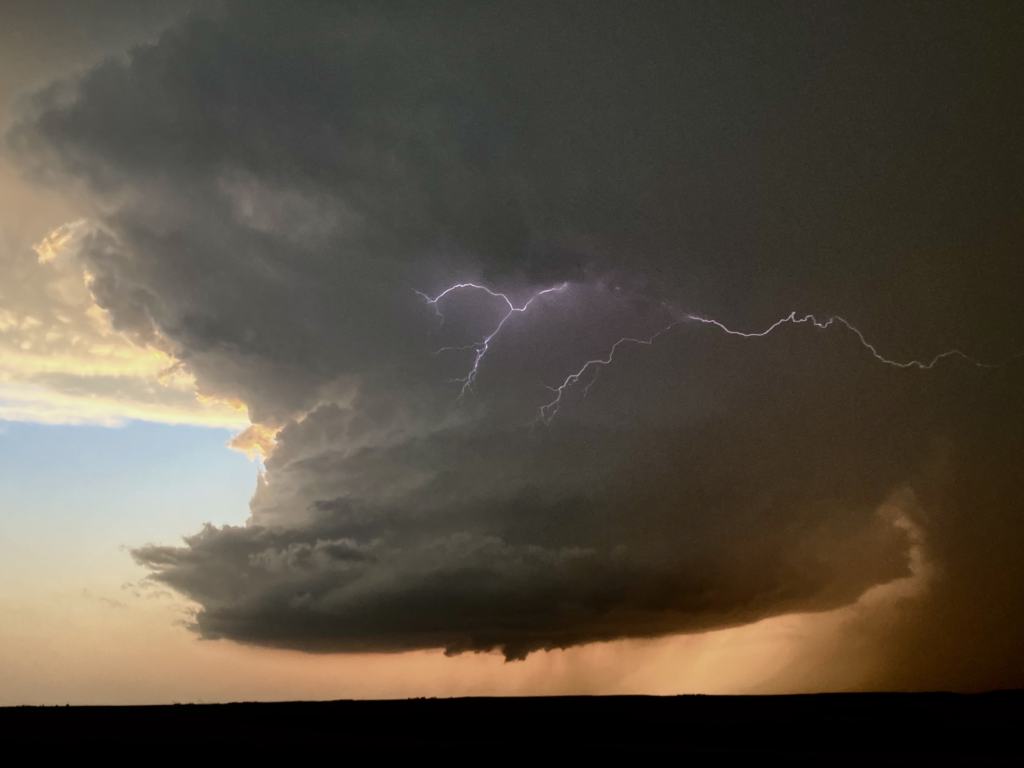
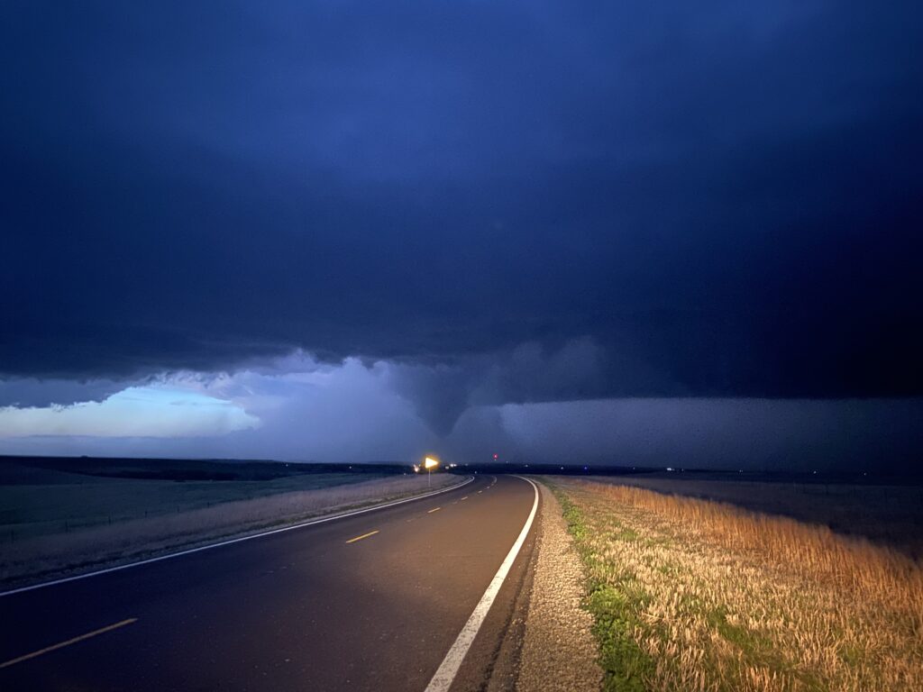
In spite of my attempts to remain stoic in the face of newbie storm chasers, I couldn’t help myself. “Holy shit”. And indeed… holy shit. What I was looking at was a classic barber pole supercell lit up on the Kansas Plains. If you want to get romantic, we were in the middle of the prairie with an unbroken view of the rolling Flint Hills all around. The early white settlers would’ve seen views like this, and the Native Americans long before them. This is what it used to be like. The supercell updraft was striated and lit up a pale purple, with brilliant shades of orange peeking through the hail core and under the mammatus-laden anvil. Although James was right that the base was flat and featureless, he must have left out the part where the mid-level meso was a barber pole and it was absolutely cranking.
It was 8:00 p.m. exactly. Or, as I’d been saying all evening, “Go-Time Showtime”.
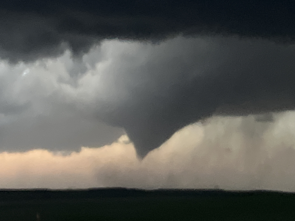
Or was the base really that flat and featureless? Just as I confidently proclaimed to Stephen and Joe that with those kind of bases we knew we weren’t going to be seeing tornadoes, a small wall cloud appeared right dead center underneath the meso.

Part of me was intrigued. Part of me was thinking that maybe the long-anticipated moisture surge was riding the LLJ as it started to kick up, and maybe we were en route to sunset greatness. But it’s hard to adjust your priors when you’re in the middle of a chase, even if your priors are already in the process of being destroyed by one of the top 5 or so exhibits of supercell structure you’ve ever seen. I was bouncing back and forth between the inside of my car and the gravel next to it, discomfited somewhat by the sheer volume of electric purple bolts of lightning that were lighting up the meso as it tilted over our heads and the anvil directly above. At one point, as I had stepped out and was standing next to Dan’s window, a piece of condensate formed that was far too narrow, laminar, and vertically oriented to be anything other than a funnel. As calmly as I could, I announced “Yep, there’s a funnel cloud. About halfway down… probably a tornado from the looks of it”.
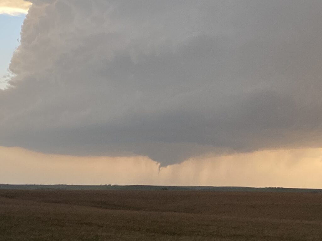
So not only had we gotten out here to see a sculpted LP supercell in the most beautiful terrain east of the 100th meridian, but it had produced a weak and semi-photogenic tornado in the first 5 minutes of us being here. Inside the car, WEAs blared as my tweet at the Wichita office likely helped them pull the trigger on a tornado warning for Cottonwood Falls and Strong City.
The time was 8:05 pm. The brief tornado had dissipated, leaving a largely featureless base save for a now-somewhat-more-distinct RFD cut in the middle of the updraft. Full of the hubris of a meteorologist who has seen a few storms so he thinks he knows it all, I figured that was the storm’s one gasp before a stable surface layer took over with the loss of daytime heating – something similar to Earth, TX on 5/16/21 or Perryton, TX on 5/26/21. Once again, I was underestimating the power of the LLJ and Go-Time Showtime.
If I’d had time for mesoanalysis, I would have seen that richer boundary-layer moisture was in fact being poured in from the south by that ever-strengthening LLJ. The dewpoint at Emporia was up to 61 degrees, whereas I’d been working with a base assumption of 58 dewpoints across the Kansas warm sector – and even richer 62-64s were on their way in from northern Oklahoma and southern Kansas. With the benefit of hindsight, I’m pretty confident that the difference between a 58, 61, and 64 dewpoint was the difference between a pretty high-based supercell, what we got, and what would have been a legendary monster like the Cole tornado just southwest of my adopted hometown, ongoing 200 miles to the south:
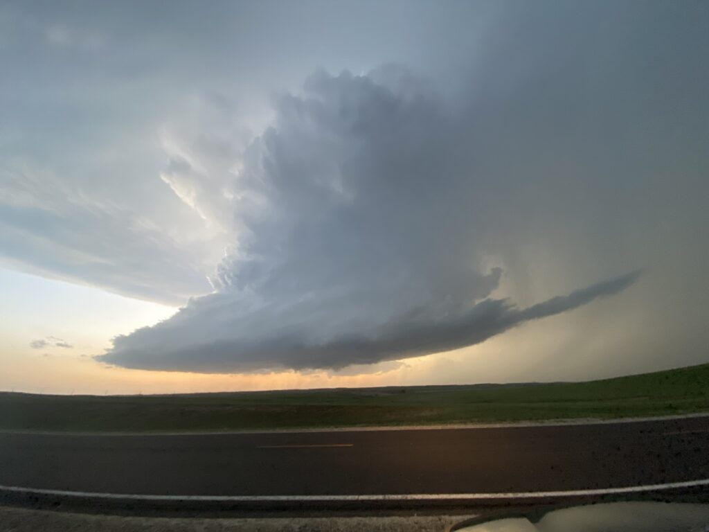
But I didn’t know that at the time. I was still in “59 dewpoint” mode mentally. So after getting our tornado for the day, I was content to sit up on top of this hill on the Flint Hills Scenic Byway and let the supercell churn into darkness. The sky already was going from a pale salmon to more of a blood orange. There were so many flashes of vivid in-cloud lightning that it took multiple tries just to get a panorama that wasn’t ruined by one.
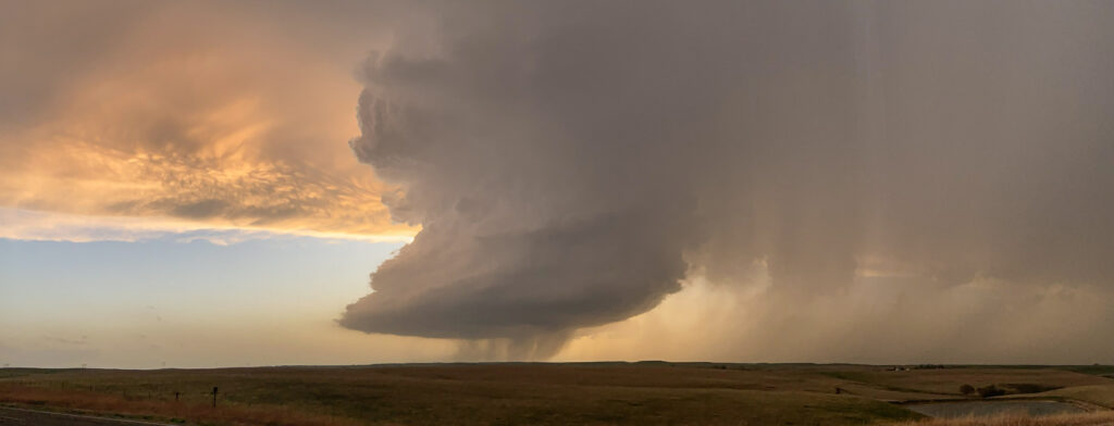
This following shot has been edited by my friend Charlie Kruschek – it’s a bit more edited than I would normally do, but you can see from the above panorama that you didn’t have to do a whole lot of editing for the colors to quickly become insane – because, well, we were awash in a sea of color.

The most underrated part of the storm, in my opinion? The absolutely nuclear nature of the mid-level meso. Some of these supercells have an innate characteristic where their mesos just seem to boil up and heave over you. It’s entrancing and I wish I could come up with a better way to describe – because truly, until you’ve sat near a powerful classic or LP supercell and just watched the motion within the mesocyclone, you can’t understand how awe-inspiring it is. On a more practical note – Dan and I were kicking ourselves for not having our camera equipment in Kansas City. This was a photographer’s dream, and we were reduced to mere iPhones.
At about 8:10, I made my one major navigation-leader-while-driving-coordination mistake of the chase. The updraft was getting closer, and so was my concern for the possibility of getting accidentally fried by a CG bolt up on this hill. Between that and the rapid loss of daylight (8:07 sunset in Cottonwood Falls), I thought a swing from the eastern side of the updraft (which was moving rather fast and going to be on top of us soon) to the southern side would provide the best light. I wasn’t even entirely wrong – I saw some decent pictures of the entire thing from the south later on:
But you also can’t fully reposition like that during Go-Time Showtime, a fact which I realized maybe 30 seconds after pulling out from the spot. Also, the Flint Hills also have Flint Valleys in between them – suddenly, there was a big-ass hill between us and the storm. It took no more than a minute or two for me to realize the stupidity of my decision and turn it back around. We pretty much ended up right back where we came from.
The time was 8:16. From here, my iPhone shots become blurry due to the awful exposure settings.
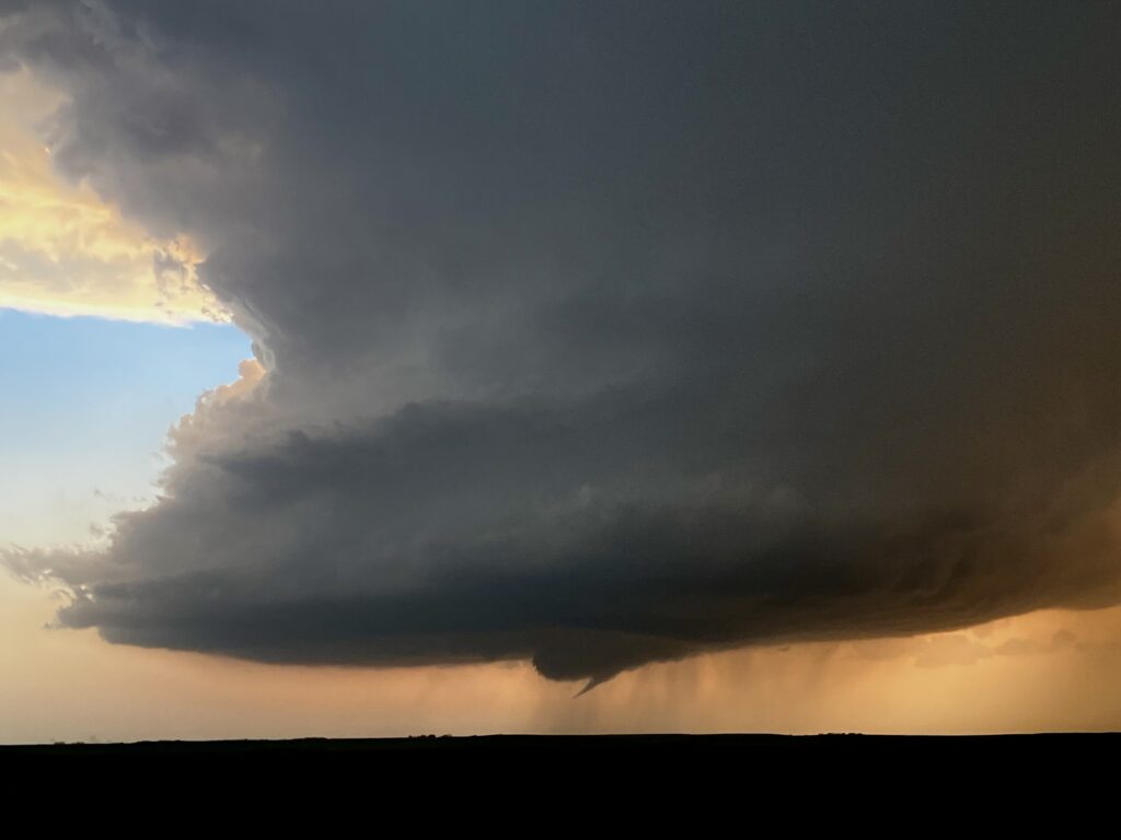
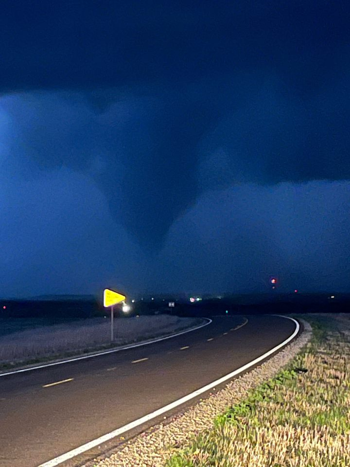
Just after this picture, the storm made another remarkable transformation in its overall structure. It had already gone from a classic-ish supercell to a pure LP updraft over the last 20 minutes while gaining remarkable definition in the updraft. Now, the low levels began to respond to the always-magical LLJ. As I sat there, quietly narrating what I saw to everyone, a classic telltale horseshoe developed to our west. At first, motion along it was all outward, and even until then I thought that the RFD cut was a byproduct of a too-negatively-buoyant downdraft that would undercut and stabilize the storm. The laminar nature of the meso just above the base seemed to indicate that as well.
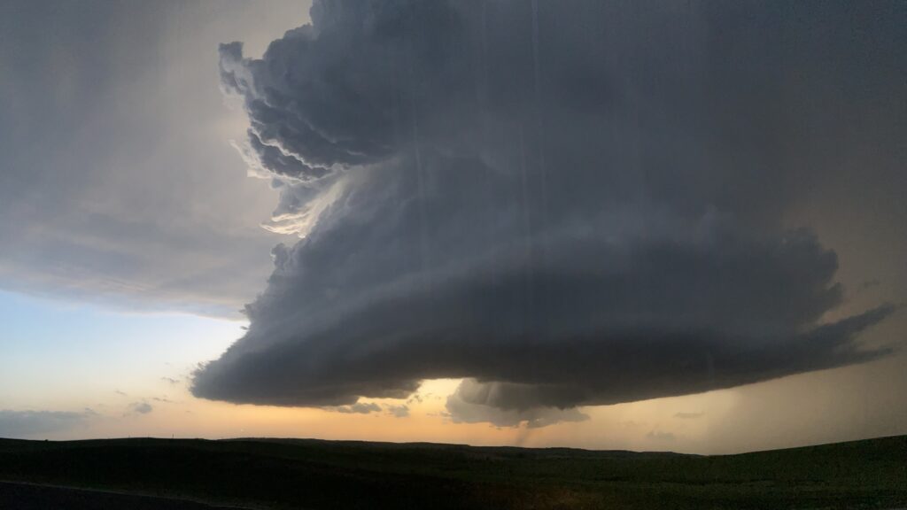
But no. Little did I know it, but a long-track EF-2 tornado had begun or was just beginning on the far northwestward side of that RFD cut. Joe and Stephen exclaimed excitedly while Dan and I traded knowing looks with each other (it took us a long time to learn not to act like the knowing sages – think of how much my storm-scale analysis had already proven incorrect over the last half hour!) But finally, I got the memo myself as this thing put down an unmistakable funnel cloud.
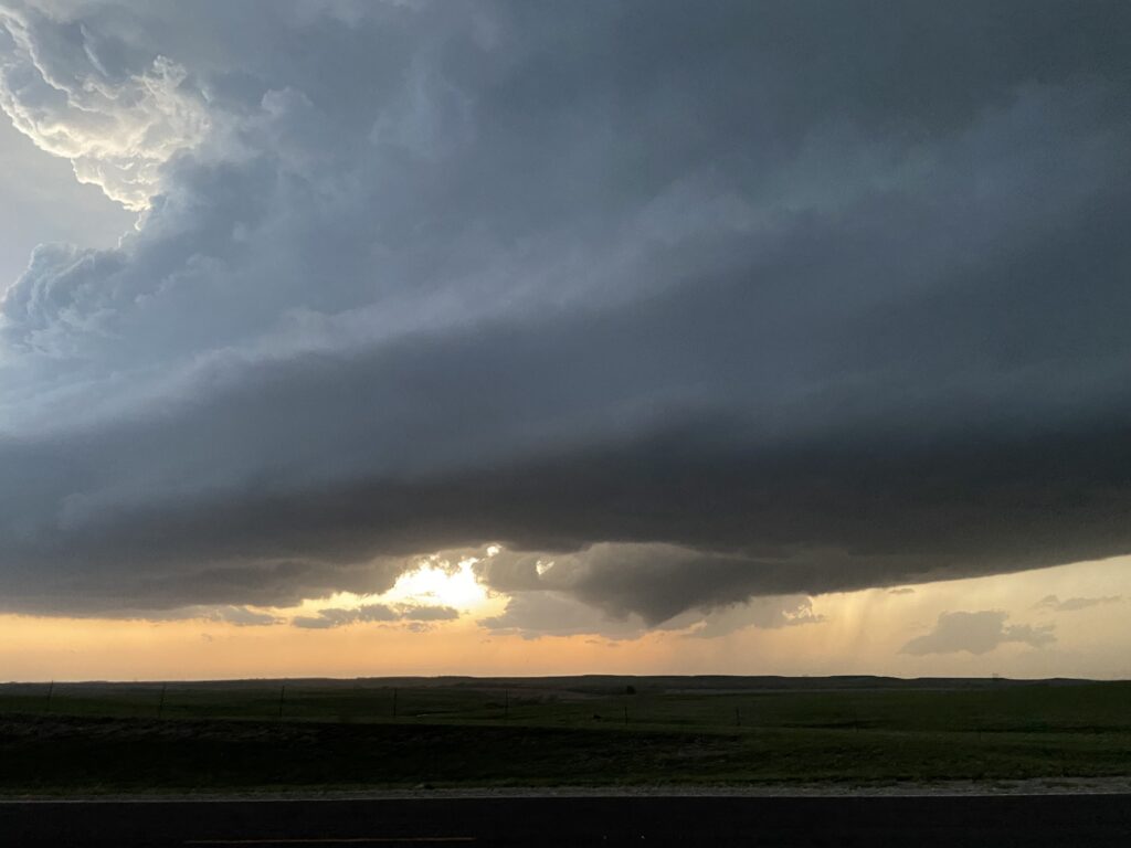
Joe was getting antsy in the passenger seat. I think he feared that the funnel cloud/tornado was going to pass right over us, and was already thinking of bailing out. Here is where I think my experience actually did do some good – I was able to quickly overrule him and make sure that we continued to watch the area of interest as it progressed (the storm wasn’t moving fast or slow, probably a steady 25 knots) east-northeastward toward Cottonwood Falls and Strong City. The pictures got blurrier, but it became unmistakable to me that we were *not* looking at the storm’s last gasp, and in fact were potentially about to witness something big time. I could see the sinking motion along the RFD cut. When that sinking motion really gets going, that’s when I’ve seen tornadoes start to do their thing and maintain themselves. It was the visual cue I needed to know that we weren’t done for the night. The images only get grainier from here.

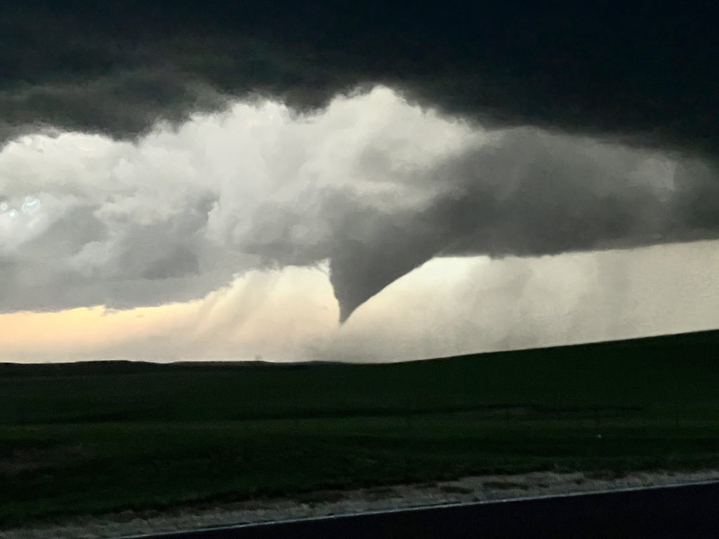
For several long minutes we watched, straining our eyes to try to get a view of whether the funnel was reaching the ground. Then, in the last picture above, a cloud of dust or debris became visible. That settled it for me. The time was 8:30, and I figured the tornado had been on the ground for about 5 minutes (it was really probably more like 8). The tapered cone funnel gradually receded, leading me to (erroneously, it would seem) believe that the tornado has momentarily lifted, but a button funnel remained.
Meanwhile, well to the west in the flanking line, there was a short-lived area of focused rotation that was either a very well-organized gustnado or potentially a landspout. I missed the best of it by several seconds, but caught the end of the feature on camera.
The time was 8:36. It appeared that the tornado threat was down momentarily, but we had a new problem: how long until it was safe to take the Byway back north to US-50 and pursue eastward? After all, softballs had probably just been falling in Strong City moments before if they weren’t still doing so right now. I decided to wait just a couple of more minutes and then get ready to follow in behind. We watched, straining against the ever-increasing darkness, when…
“Oh! Power flashes!”
So there was still a tornado in there, after all. Joe, Stephen and I all tried to photograph it while I called James to let him know there was a tornado doing damage inside Strong City.
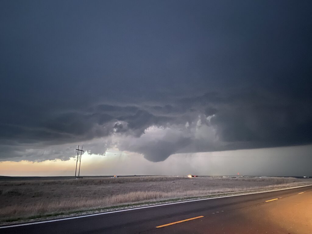
The time was 8:40 pm. Ok, screw the softballs, a good storm chaser knows when it’s time to take things into their own hands and get a little closer. I pulled back onto the road northbound and began pursuit, keeping half an eye on the remarkably consistent stovepipe/cone-shaped tornado as it translated across the road to our north and then northeast. No pictures exist from this portion of the drive to my knowledge, but if Stephen/Dan/Joe have any I’d be happy to include them. Visibility was reduced briefly by the buildings and trees of Cottonwood Falls, and then of Strong City. It didn’t look like either town had taken a direct hit from the tornado – at least on the road we were on. There were leaves and branches and minor things on the road, but nothing crazy like power lines sitting in the street or sheet metal flapping in the breeze that we could see. It turned out that the tornado had just missed the north side of Strong City and headed up into the Tallgrass Prairie National Preserve. Now wouldn’t that be a treat – to see a tornado inside the true tallgrass prairie!
Once again I began to dodge among traffic cones, this time joined by about a dozen or so other chasers who must have all been following the storm from much closer along US-50. Half of these chasers had red and blue lightbars. What are storm chasers doing with their lives? Why do they need to blind me in the dark to feel better about themselves? I’ll (sort of) give a pass to the sheriff who appeared to be chasing with his flashers on, but the rest of them? Nah.
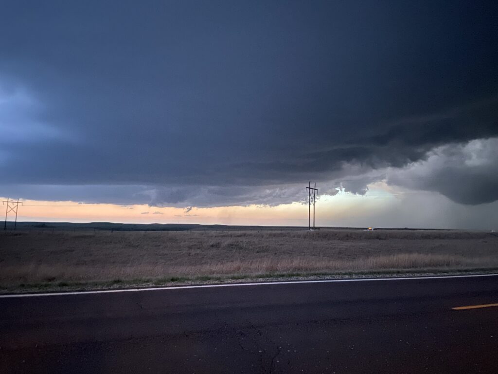
A couple of miles east of Strong City on US-50, lightning illuminated the tornado one more time. It was a “huge stovepipe”, according to Dan who in the left rear seat was in the best position to see it. The time was 8:49. Dan took video, hoping to illuminate the tornado, but I have yet to see any results from that video – mostly I’ve just heard curses about the quality of nighttime videography. The tornado began to occlude into its bear’s cage and dissipated off to the left.
Meanwhile, looking through the mini-conga-line we could see yet another big stovepipe tornado on the ground. The time was 9:02 pm. Once again, I lack visuals to be able to share with the audience given the fact that we saw it to our left and one of the two people on the left side of the car (me) was driving. Dan is our only hope for visuals here. But in the meantime, this is basically what the tornado looked like:
Pure Kansas power.
We chased after the EF-2 for a while, but as the Go-Time Showtime LLJ really started ramping up, the tornado began hooking north, and I didn’t really think we could catch it on gravel roads. I was willing enough to let bygones be bygones and cash in on one of my best storm chases ever. US-50 led back to Emporia, where a gas station awaited to let me use the bathroom and buy some jerky before the drive back up I-35 to Kansas City. The time was 9:16. We’d chased the storm for real for a grand total of 76 minutes. I pulled into the Nic and Nino’s parking lot to celebrate Stephen’s first-ever tornadoes among falling hail at 11:10, and the four of us were drinking whiskey sours and listening to awful karaoke shortly thereafter.
What a night it had been. After initially foundering, we’d gotten a nice reality check from myself to get south of Topeka and get in front of the actual convection rather than wishcasting. In the moment of doubt, Dan was there with high-level radar analysis to identify the absolutely screaming mid-level meso of our storm. And when Dan and I poo-pooed the storm’s chances of going Go-Time Showtime, it was Joe and Stephen who had the best beat on what the storm was about to do during 01Z Magic. All in all, we definitely saw 3 tornadoes, some incredible supercell structure, and an incredible lightning show, all while making it back at a reasonable hour.
Flint Hills Forever.