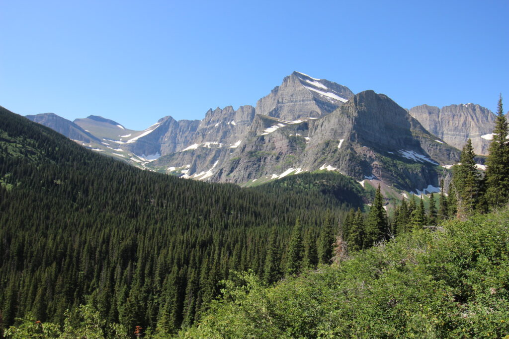
The quintessential Glacier National Park experience: driving up the long valley of Lake Sherburne on a beautiful, perfectly clear July morning. Pulling over along the way to spot bears in the distance. Driving into a beautiful, craggy mountains with snow shining on their flanks. And then embarking on foot on a journey that takes you past a succession of lakes that keep getting more beautiful, somehow.
It was July 17, 2022 (happy 55th birthday to my dad!), and this was our own quintessential Glacier experience.
Elizabeth and I popped out of our tent early-ish in the morning – not as early as some of the days prior in the trip, but an impressive showing given how late we’d stayed up watching the planetarium show the night before. It wasn’t going to happen without coffee on this particular day, but for that Elizabeth had the assistance of the Glacier Perk Cafe in St. Mary. It was still before 9:00 by the time we got on that aforementioned road down Lake Sherburne.
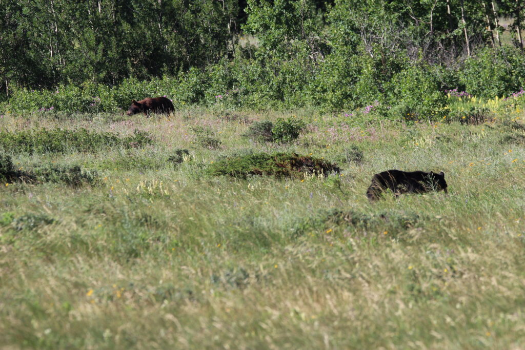
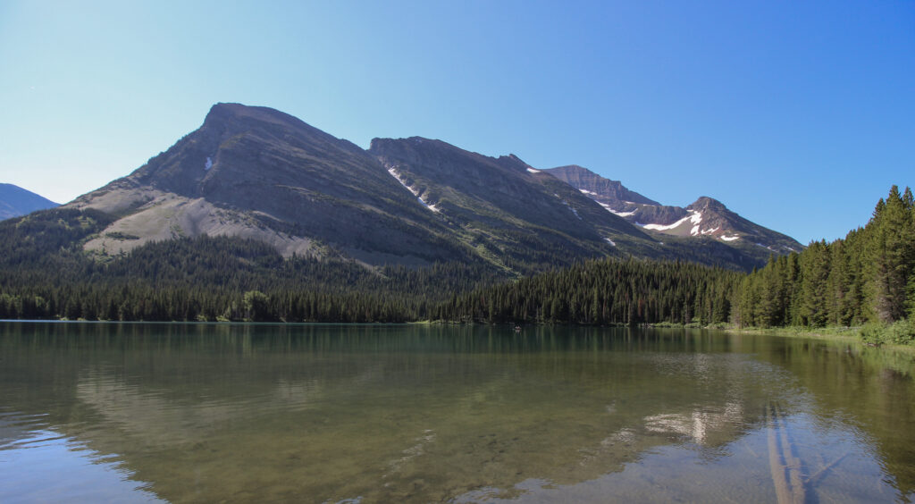
No more than a mile or two short of the Many Glacier Hotel, the road passed by a several-hundred-yard-deep clearing that offered a sweeping panorama of Wynn and Allen Mountains in the distance. A few cars were pulled off of the left side of the road. We followed the old number one rule of any national park: if someone else is pulled off, you want to pull off as well. And indeed, a couple hundred yards away at the treeline, there was not one but two fully grown bears, just doing whatever it is that bears do.
For a while, “whatever it is bears do” seemed to involve coexisting peacefully in the meadow. After all, it was a beautiful July day to go eat the tens of thousands of calories that a bear must eat to be ready for the winter. If you’re busying roaring at each other, you can’t go and get those calories consumed. I had plenty of time to grab the camera bag, fumble with lenses, flip on the Big Dog, and hand Elizabeth the camera so that she could go wildlife hunting.
A small crowd gathered around us, wanting to see the shots of the bears through the scope. It was a funny callback to a similar situation in the Lamar Valley of Yellowstone the previous year, where I’d been the one asking.
Then one of the bears popped its head up.
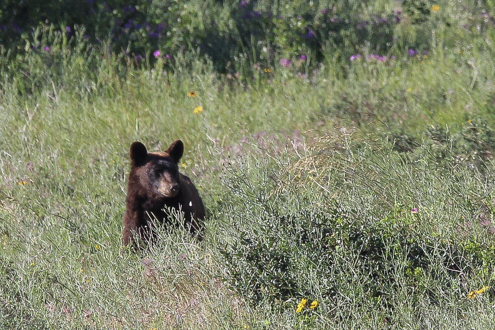
And just like that, there was no longer room for both of them to munch on wild huckleberries or whatever they were doing in this particular meadow. The brown one (that I think was a black bear, but maybe is a grizzly? The ears look too big to be grizzly ears, but it does seem to have a bit of a hump) took off at a pace that forced an involuntary “ohhh” from the onlookers. The black one took one look and skedaddled into the woods.

A moment or so later, a *third* bear emerged into the arena, only to realize that it also had bitten off more than it could chew. The brown bear turned around and gave this interloper a chasing of its own. Then it returned to enjoying its morning.
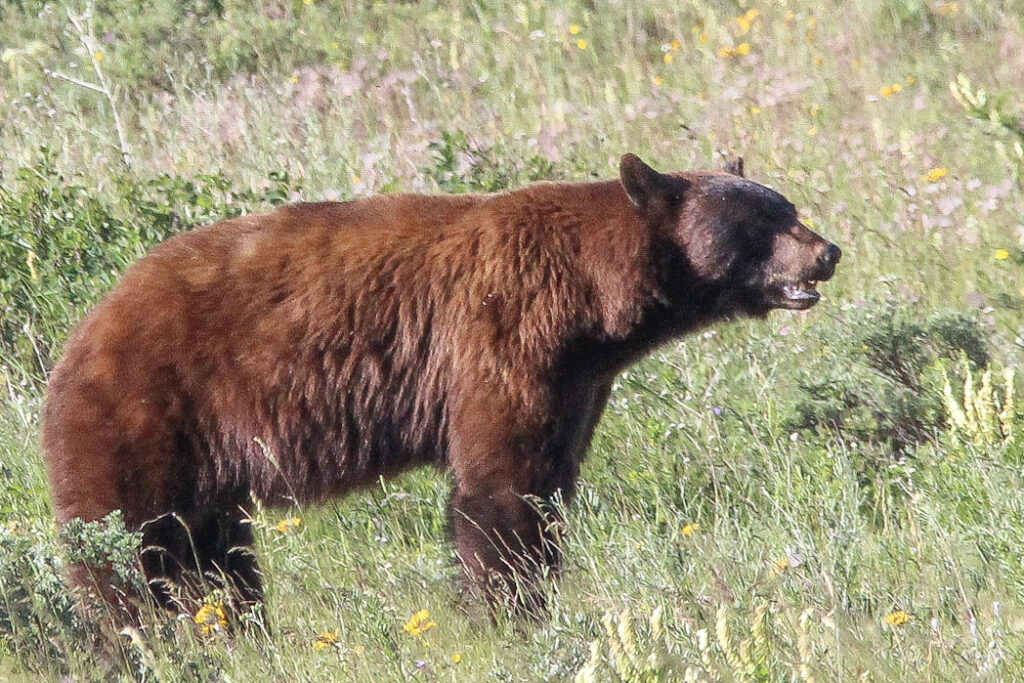
That brought our official Bear Count in Glacier National Park from 2 to 5. And we weren’t done yet – the counter was still to be raised. What an exciting and thrilling way for the day to start (and also, what an unbelievable job that Sam’s lens plus Lightroom did to bring this bear to life from 200-300 yards away).
As it had been doing all week, snow in the high elevations was playing havoc on our hiking decisions. Highline Trail had been closed, Siyeh Pass had been largely unpassable, Piegan Pass had only been reachable by the narrowest of margins – and our best knowledge was that the trail up to Grinnell Glacier was closed. That galled me a little bit – what point in being in Glacier if not to touch one of the eponymous glaciers before they were gone forever? Our plan was to hike up to Iceberg Lake – an acquaintance of mine who had made a spur-of-the-moment decision to visit the park at the exact same time that Elizabeth and I were making our long-awaited visit had actually hiked up to Iceberg Lake the day before. Iceberg was extremely high on Elizabeth’s priorities list – it had come highly recommended by my Aunt Kelly, in fact. So we decided to put in one more long, grueling 10 miles and 1,500 feet in elevation. And in fact, it presently turned out that we could add another tenth of a mile or so each way, because the lot at the Swiftcurrent Motor Inn was already full. Street parking down the length of Route 3 kicked us all the way past the Many Glacier campground and halfway back to the Grinnell Glacier trailhead.
But no matter. A few minutes later, Elizabeth and I were walking in rear of the Swiftcurrent Motor Inn to the spot where the Iceberg and Ptarmigan Trails departed. Early indications were that this would be a trail packed full of little piggies – our just desserts for starting the day late.
And then the reality of nature struck in the form of a ranger posted at the trailhead. Somehow, in just the past day, bear activity had picked up down the trail, and park officials had moved to close the Iceberg Lake and Ptarmigan Tunnel routes altogether. While disappointing, it was a good reminder that we were in one of the few places left in the Lower 48 where humans are emphatically not at the top of the food chain, and we don’t just force animals out of the way for our own whims. It was sort of powerful, in a way.
But the closure also necessitated a plan B, pronto. After a quick talk with the ranger, we ascertained that our second-choice trail, the Grinnell Glacier Trail, was at least open as far as the overlook over Lower Grinnell Lake. Above that, deep and highly angled snowfields forced the trail’s closure, as another ranger posted at the Grinnell Trailhead informed us. Still, that left enough space for a 6-mile round-trip hike, most of it pretty damn flat along the chain of lakes leading upward to Grinnell Glacier, and one of the most iconic views in the continental US waiting for us at the top. I was in.
The trail opened through a vast forest of huge pines (lodgepoles, if I had to guess?) along a wide, flat nature trail. Its accessibility was matched probably only be the Trail of the Cedars that we’d hiked four long days ago (gosh, remember how long ago that blog post was?). It was crowded, but could have been much worse. According to my camera logs on my iPhone, we reached Swiftcurrent Creek at about 10:00 am after 15 minutes of hiking and 30 minutes after parking along the side of the road. Another five minutes or so, and we were walking along the absolutely gorgeous western bank of Swiftcurrent Lake, far upstream of the Many Glacier Hotel. The day was calm enough to let a spur of Allen Mountain reflect in the shallows of the turquoise lake.
In other words, it was a perfect morning to hike. The crowds thinned out quite a bit past Swiftcurrent Lake, though this would be a much more crowded trail than Piegan Pass overall.
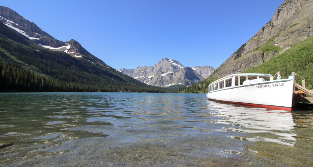
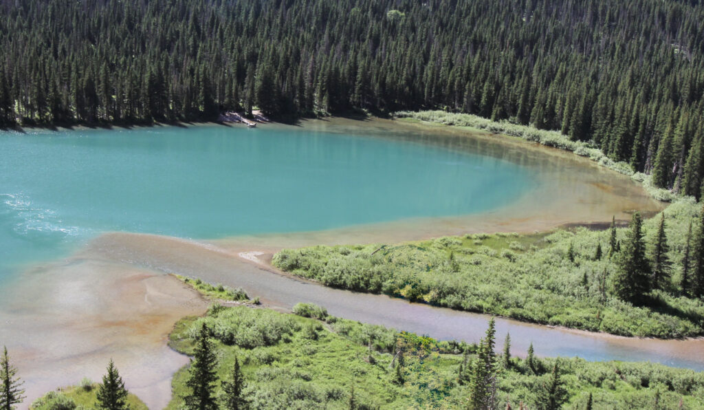
The waters of Grinnell Glacier (and Cataract Creek, which begins at Piegan Pass) carve out a chain of 3 lakes via Grinnell Creek prior to emptying into Swiftcurrent Lake. The last and largest of the three is Lake Josephine, a mere several hundred yards further upstream. For accessibility reasons, you can actually take a boat to a dock at the head of Swiftcurrent Lake, walk a very brief and flat portage, and then hop aboard another boat that will take you across the elongated Lake Josephine. Elizabeth and I had talked about taking this ferry as a way to save some wear and tear when we’d been (unrealistically) planning on hiking the Highline Trail, Crypt Lake Trail, and up to Grinnell Glacier in 3 consecutive days. With our Waterton Lakes day having served as something of a respite from the hard week of hiking, there seemed to be no reason to spend that much money. Still, it was interesting to walk the stretch of trail that followed the portage. And when we popped out at the boat launch for the Morning Eagle across Lake Josephine, it was clear: we’d leveled up from “Glacier National Park” to “Glacier National Park”.
It’s a testament to how incredible the rest of this day was going to be that that’s not a top ten shot of the trip for me. Although it’s close.
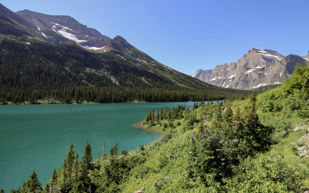
The trail wound around the north (right) bank Lake Josephine, in the narrow ledge you can sort of see beneath the sheer rock face (by the way: the trail followed the side of Mount Grinnell, leading back from the triangle-shaped Grinnell Point you can see from the Many Glacier Hotel toward its peak hidden back by the glaciers). Here we popped out of the thick pine forest and into more of a scrubby terrain, with shrubs almost higher than Elizabeth reaching out to tickle us on either side of the trail. The sun rose higher into the sky. Time fades the memory, but photo timestamps and geotags suggest that we got to the Lake Josephine Boat Launch by 10:15 and had made it almost a full mile to the upstream end of the lake within half an hour. Most of it was flat, but there was a small incline at the end that led to a spur trail down to the other side of the lake’s headwaters. From this incline, we got a sweeping view backwards of Lake Josephine. With a little bit of altitude over the water, the blues began to look even more brilliant.
It was an epic hike that was only getting more epic by the minute.
It was also getting warmer by the minute. It was a testament to the absolutely gorgeous last few days that we’d had that I’d barely felt the temperature at all. Today was definitely the warmest of the days, and hiking up the north wall of the valley undoubtedly did not mitigate that. I finished the last of the lukewarm water inside my Lifestraw bottle. Normally, this would be a cause for concern, but it was a Lifestraw bottle. All I had to do was wait for the next trickle of snowmelt that we splashed through, then stick my bottle into the mini-waterfall like it was a water fountain at an airport. Fresh, completely clear, ice-cold water filled my bottle in seconds, to be drank through the filtered straw in the center (to be honest, filtering this water was probably overkill. It’s freaking glacial melt).
This was about the 2-mile mark of the hike. The trail was closed at the 3-mile mark up ahead. But for now, Elizabeth and I would have to hike the last mile uphill – unlike the extremely flat previous 2. It wasn’t anything horrible, but AllTrails suggests we had to make about 600 feet in that last mile, which does make for a pretty steep little climb. Elizabeth had to start taking shade breaks under the meager pines that grew along the trail, which slowed us down some. For the first time, we started encountering hikers who’d already been up to the trail closure and were on their way back down. The hikers were of a distinctly less outdoorsy vibe than on Piegan Pass – families with kids, Instagram girls, the like. But they were all cheerful, and we kept taking turns stepping off the narrow trail to allow each other by.
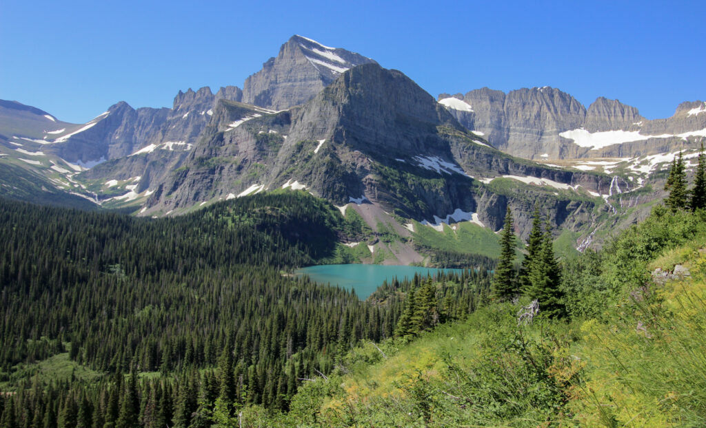
The higher we got, the more we got a view of the famed duo – Mount Gould and its northern spur Angel Wing. In the Morning Eagle picture above, you can see them directly in the center of the photo – the pointy peak and its spur down and to the right. (Bonus fun fact: in the photo below, Piegan Pass is just barely visible on the left side of the line of peaks. It was cool to see something we’d seen two days before).
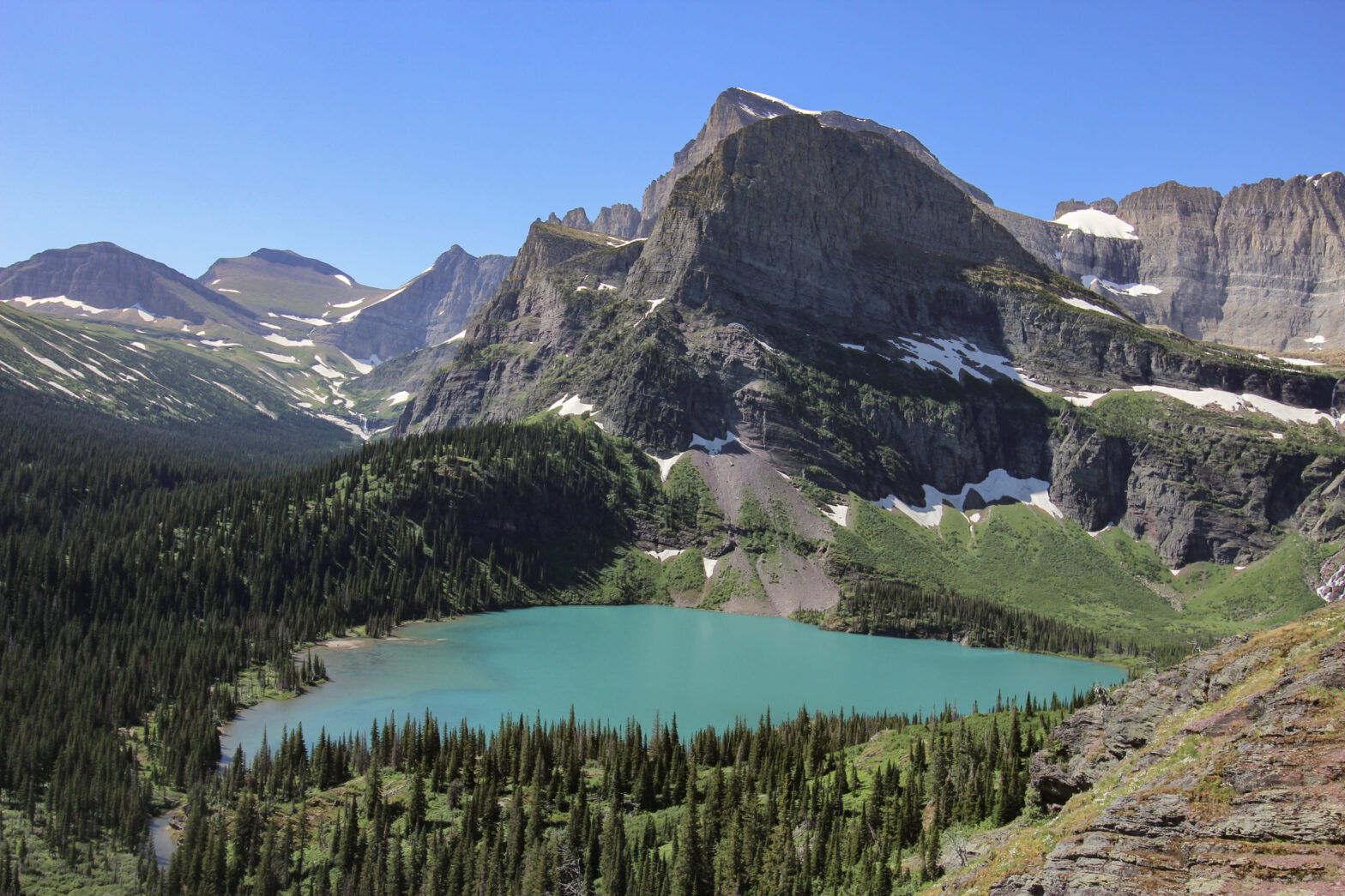
At the bottom of Angel Wing is the lake that brings about maybe the most famous photography spot in all of Glacier National Park: Grinnell Lake. The waters of Swiftcurrent Lake are “glacial blue” if you know where to look. The waters of Lake Josephine were shockingly blue. But Grinnell Lake is of a blue that can only be topped in a select few spots in the continental US. And step by step, it started to come into sight.
I’ll save the poetics for a couple of paragraphs from now once Elizabeth and I had gotten to our destination. This keeps in line with our actual hike, which had become difficult enough to require a good chunk of my (and all of Elizabeth’s energy). But I couldn’t help but note as we plodded further uphill, we started walking through stands of purple, white, and yellow wildflowers in the middle of a brilliant bloom. Because of course.
Alright. Enough beating around the bush. Let’s get to the good stuff. The trail reached about the 3 mile mark where it made a short, sharp 1-2 of switchbacks on the side of the mountain. At the first of these switchbacks, people congregated on every available rock, for this was the trail closure. The amount of hikers there should have felt annoying, but it didn’t. This was the kind of view that everyone deserved to see in their lives.

I promise you that if anything, the picture *fails* to do justice to the beauty of Grinnell Lake. Words certainly can’t do it justice. Angel Wing loomed over it, somehow both an imposing figure and yet also seemingly so close that I could reach out and grab it. Way down on the left shore of the lake, you could see people splashing on a tiny beach and sandbar. And to somehow add to it all, there was another one of those stands of blooming wildflowers at the trail closure. The picture below has been hanging in our guest room for months now, forever immortalized on canvas.
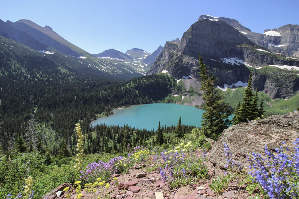
So this is where I run the risk of sounding like a cornball. Because oftentimes, I say “wow, this thing was awesome”, which is true because honestly there’s a lot of awesome places out there. But this. This was as close to a transcendent experience that I think I’ve had. It genuinely felt like Elizabeth and I (and about 50 other people) were sitting on a red rock in a little slice of heaven that God had sent down to Earth for us to enjoy. And to see that, especially in context of the diminishing glaciers in the park and the threatened status of the ecology – it was just special. It felt like an honor to be there.
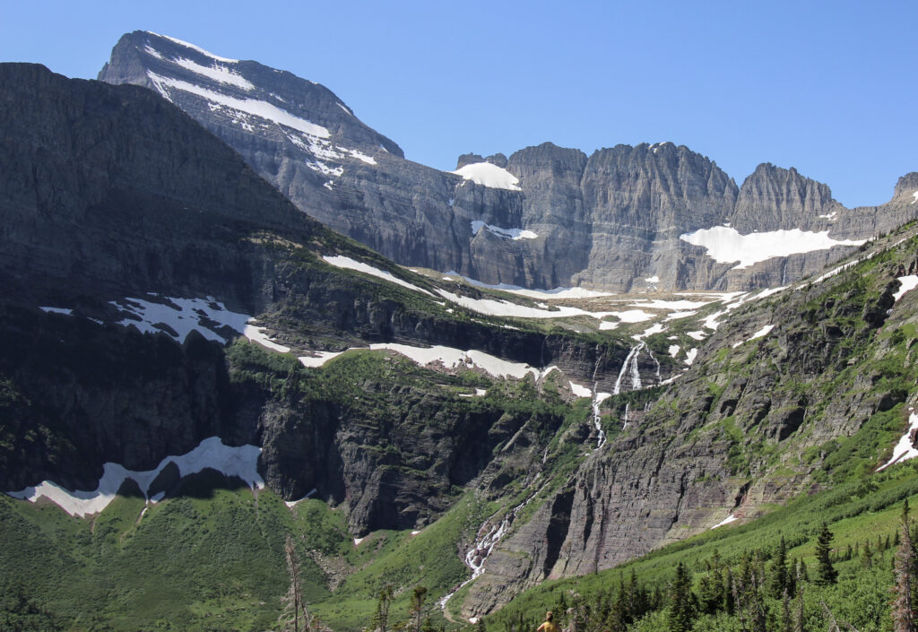
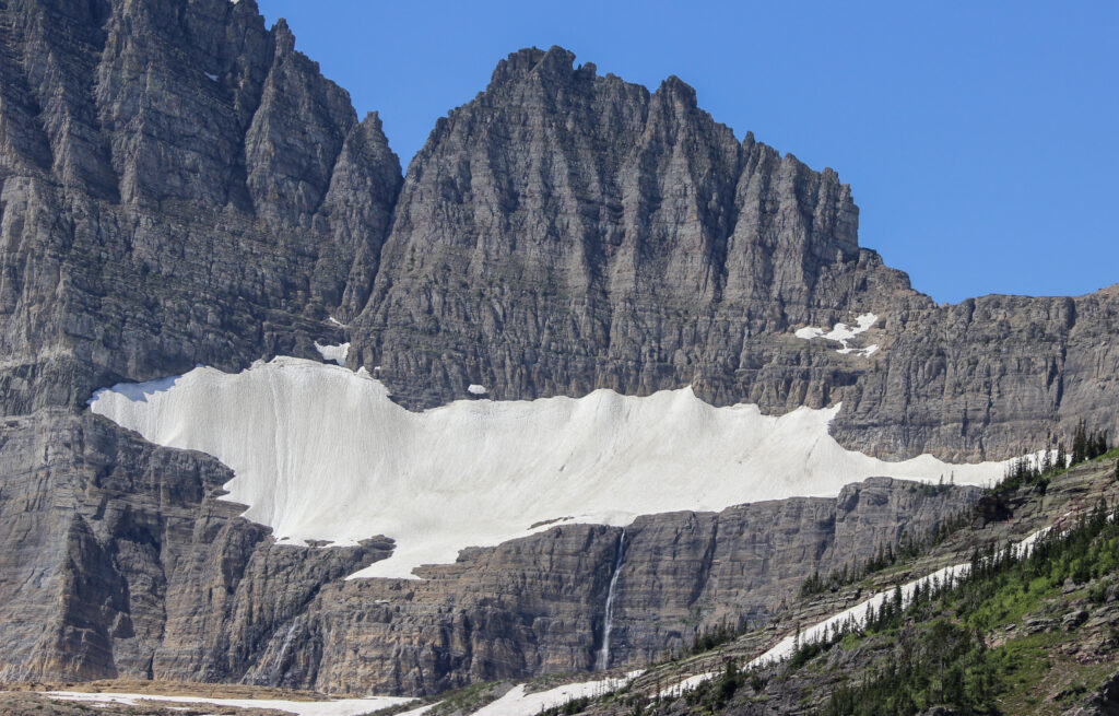
We ate a hiker’s lunch rich in goldfish, Go-Go Squeeze, and granola at the trail closure. There wasn’t any need to rush – in fact, we spent darn near an hour up there, soaking it all in. There was a lot to see – apparently there had been mountain goats further up Mount Grinnell early in the day, but we never saw them. At the top of the glacial valley that we’d been hiking on, Grinnell Falls tumbled down from the glacier, which was mostly hidden just barely out of view. But we got a pretty good look at Salamander Glacier from our viewpoint. And Salamander Glacier was nestled into another razor-thin section of the Garden Wall. Pretty cool to think that we’d basically hiked to within a (long) shouting distance of Going-To-The-Sun Road.
Let’s zoom it in on Salamander Glacier, since that was as close as Elizabeth and I would get to achieving our dream of touching our first-ever glacier (we finally fulfilled that dream a year later in Iceland).
It was a bit of a bittersweet realization, I won’t lie.
Here I am describing this mega-adventure, and yet it was only 12:30. After drinking in the scenery, Elizabeth and I are started back down the mountain. We’d talked that morning about potentially swimming in a glacial lake, and I had thrown my swimsuit into Elizabeth’s Camelbak just in case. What I think decided the thing for Elizabeth was the increasing warmth of the day, and all of those ant-sized people frolicking in Grinnell Lake below. After all, she’d missed out on my bath in the St. Mary River the night before. Our last showers had come at the Belton Chalet way back on the 13th, and this was now the 17th. Desperate times called for 34-degree water to clean you off. So when we got back to the head of Lake Josephine, we took the spur to the right. It was time to go for a little swim.