(This is part two of the post series covering our October 14 along the Oregon coast. Previously, I wrote about our drive up the Oregon Coast Highway from Newport to Pacific City).
It had already been an incredible day by any measure. Volcanic beaches, seals, lighthouses, whales, arches, rocks, big waves, tiny rivers, and beer: my parents were experiencing vacation at the frenetic pace that Elizabeth and I usually push ourselves on. It was now mid-afternoon, and we were making one last detour on the southbound trip back from Pacific City to Newport: this took us inland on State Highway 18 (past a pasture in which Elizabeth excitedly yelled there was a bear, only for me to zoom in on it with the camera and discover that it was in fact a horse), then to Schooner Creek Road. No more than a mile from that turn, we came upon the first of two stops I had planned in this area: the Drift Creek Covered Bridge.
Now, everyone loves covered bridges. I get that there’s some polarization out there in the world when it comes to just about anything. There are people out there who hate things just to hate things. But even those people don’t hate covered bridges. The Drift Creek Covered Bridge has a cool story: it was built in 1914 right next to the coast on a major north-south route. When the Oregon Coast Highway was built in the 1960s, the bridge was bypassed, and the local community preserved it as part of their heritage. Unfortunately, it began to fall apart, so a family took ownership of the bridge and moved it to their property, where it’s now part of their driveway spanning Bear Creek. Very cool stuff! I want a covered bridge in my front yard when I’m older and richer.

It did indeed span a little tumbling creek, too.

Pretty neat stuff. The four of us walked the span of it, took some pictures, and enjoyed the mountainous rain-forest vibes of the spot for a couple of minutes, but then it was time to keep moving.
There was some question about whether we could even reach our next and final sight-seeing spot: the Drift Creek Falls trailhead, up another 8 miles. The GPS said those 8 miles would take a whopping 25 minutes to drive. But the GPS also said that the route would be unpaved, and so far the road seemed to be pretty well-paved… But after a few minutes, we turned off of the local road onto an even more remote national forest road. And it became clear that this would, if anything, take *more* than 25 minutes. I did not envy my dad, driving a big rental car on a narrow road that was going way uphill in a short span of time. But it makes sense – if you’re going to find a waterfall, you do have to go up into the mountains to find it. The road was windy, twisty, topsy, turvy – the trees went from the relatively tame coastal forest into a true Pacific Northwest dream, with absolutely massive cedars towering hundreds of feet from the mountainsides alongside us. At one point, we passed a hollowed-out hulk that must have been a car that had been in accident at one point and was in too remote a spot to be saved. I gulped; after all, we’d only come here at all on my recommendation. You can imagine my relief when we pulled into the nearly empty parking lot for the Drift Creek Falls trailhead and safely parked the car.

It wasn’t too hard to figure out why the trailhead was empty: it was 4:30 and the sun was due to set in about two hours. It was just pushing the limits of comfort to start this trail in a dense forest right about now, but we should be able to finish the 3-mile round-trip trail and be back down at sea level before it got dark. Probably.
And so we set off into the humid Oregon mountainside, heading downhill toward the Falls 500 feet below. Over the first five or so minutes, we passed by 3 or 4 groups on their way back up. Doing the math in my head, I counted and realized that this basically made up every remaining hiking group whose car was in the parking lot. So I started calling out “Hey, bear” at the lead of the group every so often. Elizabeth and my parents seemed to think it was a good joke, but if I was a black bear I’d want to live in Oregon’s Coast Range (we looked it up the next day. There is a large black bear population in the area). So it just felt like the prudent thing to do.
No bears appeared at any time during the hike, but we weren’t totally bereft of fauna. We hadn’t even left the trailhead when my dad caught glimpse of a HUGE slug on one of the signs. A banana slug! Opinion was sharply differentiated by gender over whether banana slugs are very cool or extremely disgusting. I will leave it to the reader to decide where they come down on the debate:

There were probably a total of 5 or so banana slugs that we saw right on the trail. Goodness knows how many others were hanging out just out of sight.
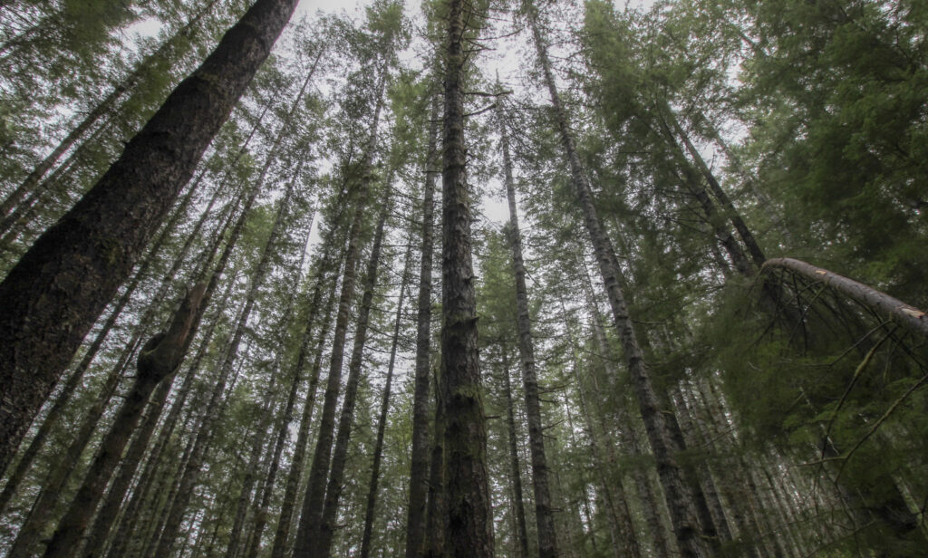
The slugs were there to be found at eye level, but there was no limit to the vertical depth of the forest around us. As you can probably tell from the pictures I’ve already posted, this was the definition of the great North American rainforest. Here we were at 800 feet above sea level just a few dozen miles from the coast – perfect for upslope, upslope, upslope. Everything was a brilliant green, soft, damp, wet, rotting, fresh-smelling. Maybe my reaction wasn’t quite so visceral in my second trip to the Pacific Northwest after the truly spell-binding first visit to Washington in January, but still: I could live with this kind of scenery and not be bored for a long, long time.

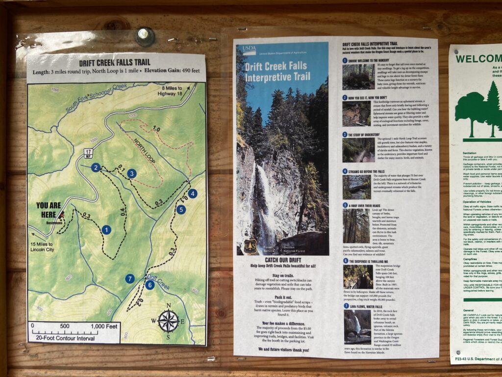
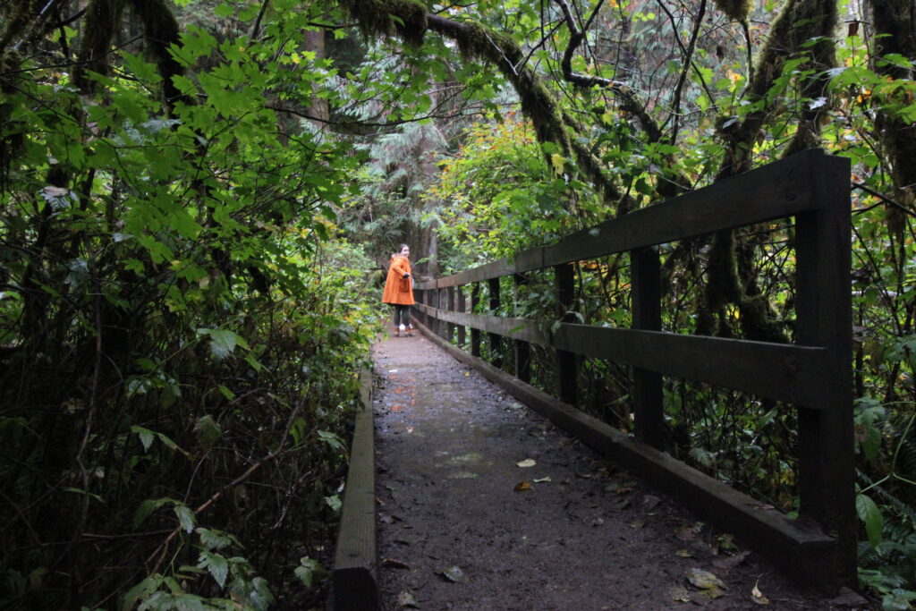
The trail took us down toward the right bank of an ephemeral stream, then over a bridge and hairpinned back down the left bank. It was at this bridge that I discovered that those numbered points on the map above are also marked along the trail – and each one is an educational opportunity. Not only was it a foreshadow to the Y Trail in Provo a month later, but it was a fun little rejoinder in the middle of the trail. More trails should include educational content like this.
After the big hairpin down the left bank of the streambed, we hiked a short way until coming to a wider creek at the bottom of the valley. The trail bent back to the left so that it could continue downhill into the valley of the wider creek, which one of the signs noted was actually the one that supplied most of the water to the Falls. We crossed on a muddy bridge over the rambling waters.
Here’s the elephant in the room, as I go back and edit these pictures: as beautiful as this location was, I totally biffed the photography. Everything came out blurry, or with the cloud cover in the background completely washed out, or horribly out of focus. I guess I’ll blame it on a inexperienced photographer in an extremely tough situation (humid environment, tough lighting, lots of targets, and water on the lens earlier in the day), but my phone did the exact same thing. Can’t even have a crappy backup! So please enjoy my 6th-grade-caliber photography.
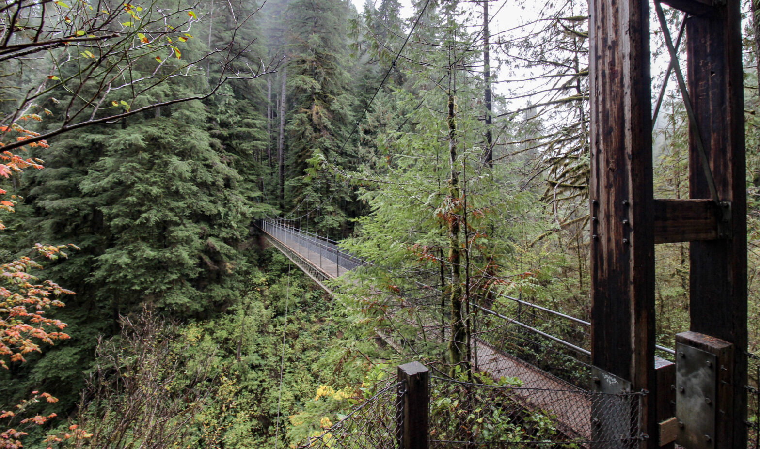
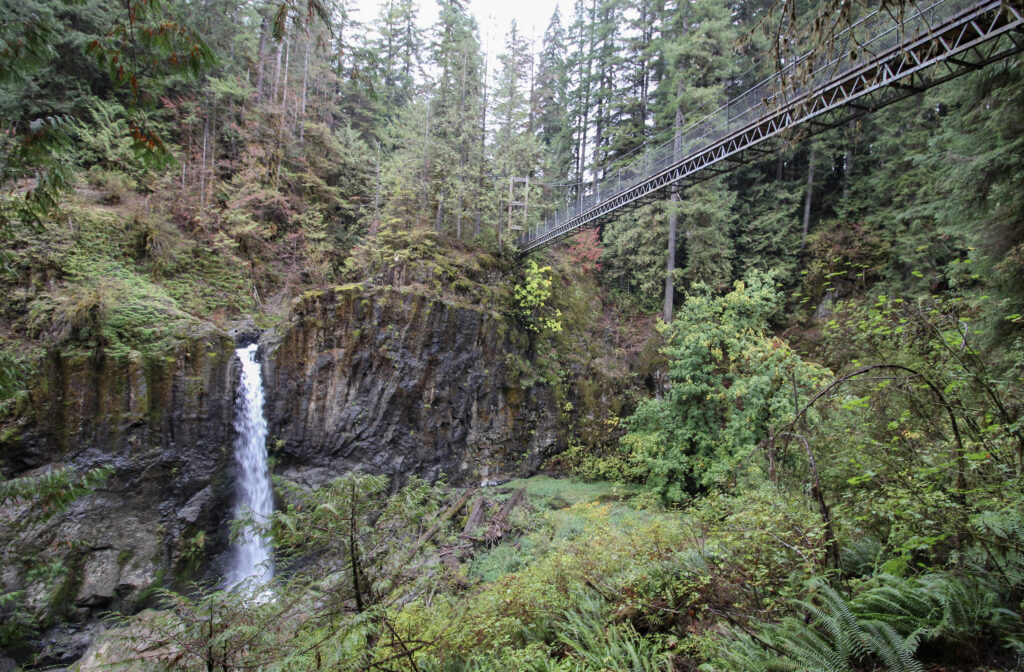
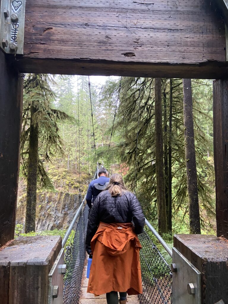
There wasn’t a whole lot longer to go from here. After a few minutes, the sound of cascading water percolated from ahead. There was a big opening in the otherwise ubiquitous tree canopy on the left. And then, just like that, there was a big old suspension bridge right in front of us. I guess I haven’t mentioned the suspension bridge yet. It was a key draw of the Drift Creek Falls Trail. To cross Drift Creek, which forms a sizable canyon as it receives the waterfall, someone stuck in a 240-foot-long suspension bridge in the mountainside a full 100 feet above the water below. Elizabeth and I had seen a few pedestrian suspension bridge videos in 2022 and I was super keen to hike one. I think my parents were pretty excited to see it, though they maybe hadn’t fully internalized it. I know Elizabeth was feeling nervous to cross such a high-up bridge.
And there it was. A massive wood superstructure anchored in on this side of the canyon, and then a sturdy-looking metal bridge with wood planking and big railings on each side. Elizabeth visibly relaxed next to me. It looked very safe, and most importantly, it looked very, very epic.

Elizabeth and my mom were the first two out onto the bridge. It swayed slightly on their feet as they walked out to the center, then turned around so I could get their pictures (unfortuately super washed out). Then it was my turn to walk out there. There was a little bit of give, but nothing like the bridge near Grinnell Lake in Glacier in 2022 (that blog post will be coming in the next few months probably/maybe/never). I got out about halfway and was rewarded with a view of a gushing Drift Creek Falls. It was pretty awesome – not as much water as some of the other iconic falls we’ve seen in recent years, but extremely unique. In fact, with some basalt columns nearby, you could be forgiven for ignoring the trees and just seeing the waterfall and basalt and thinking you were in Iceland.
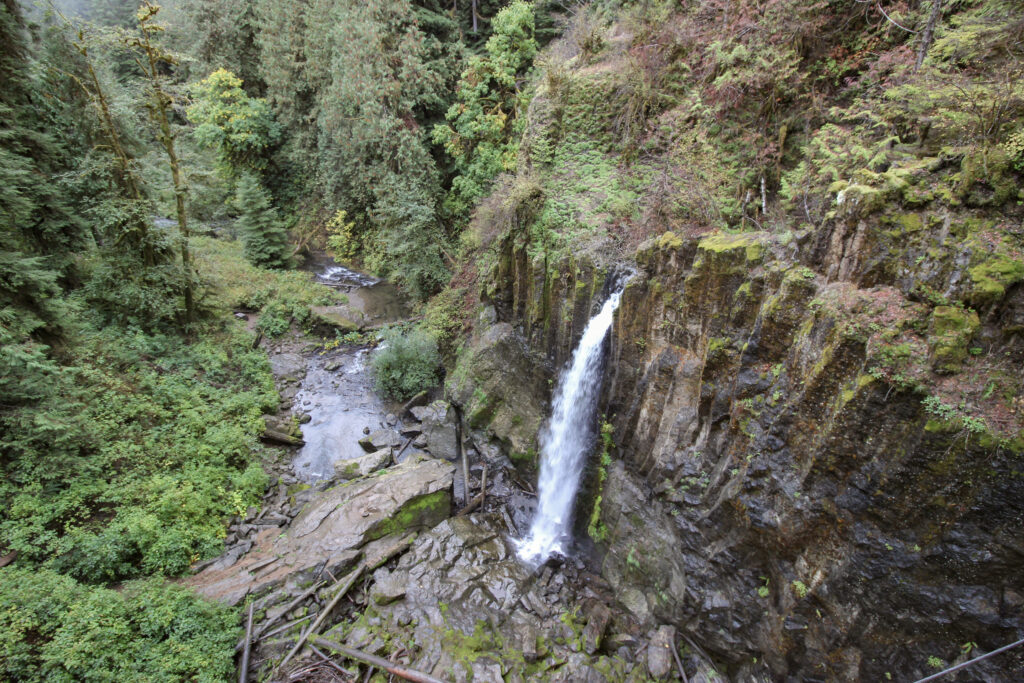
On the other side of the bridge, there was a little viewing area where you could see back across the chasm and get a head-on look at the waterfall. Plus, you got a rocking view of the bridge.
Once again, I apologize for what was not a very good day from my camera. Elizabeth took a long exposure on her iPhone that actually nailed it pretty well:

Thank you to my wife (and to my mom, who was the one who showed us how to use the live pictures to take a long exposure) for always saving the day.
I worked like a busy beaver for about 10 minutes taking pictures and trying to enjoy the view before my mom pointed out that it was now 5:30. The sun would be down in 1 hour, and we still had all of those miles of sketchy national forest road to deal with to get back down to sea level. So with a final regretful watch of the cascading fall, we tramped back across the suspension bridge and then started the modest uphill to the car.
I was surprised how well everyone was able to maintain a hard pace back up to the car. I hadn’t pushed it lightly, given how close we really were to sunset, but nobody complained or slowed down all the way back up the hill. The lone interruption came in the form of loud booms a few miles behind us that caused quite a consternation. Dynamite? Gunshots? Trees falling down? I’ll never get the answer, but whatever they were, they didn’t come any closer. We got back to the trailhead (which by now was almost entirely deserted), then my dad set an admirable if a bit nauseating pace back down the hill. By the time the gloom darkened into dusk, we were safely back on a main road and cruising toward the Oregon Coast Highway.
Such a long day of hiking and sightseeing left all of us in a state of hunger/hangriness ranging from “want food” to “oh boy”. I found a pizza company back in Newport called the Cobblestone Pizza Company and my dad set a course to it, all while the beautiful sounds of Notre Dame kicking the crap out of USC filled the car from SiriusXM. I would describe the pizza more as “filling” than “delicious”, though everyone more than ate their share and I added some pretty damn good boneless wings on top. To complete it all, we each had a bit of the remaining blueberry fudge from Otter Rock that morning. As tired as everyone had been the night before from travel-related complications, my itinerary today had left everyone ready to collapse from the moment they got back to the hotel.
If this was to be the defining day of our Oregon trip, it had been an awesome one. We’d seen so many different things in such a short span of distance and time – the diversity was a pleasant surprise. Although there were many contenders, the hike down to Drift Creek Falls was my favorite thing of the whole day. I was glad we – barely – managed to squeeze it in.
I laid down in bed and didn’t take long to fall asleep. We still had one more full Sunday in Oregon, and though tomorrow wouldn’t be as action-packed as today, little did we know that the most incredible part of the coast still laid ahead.